
PALISADES FIRE
After starting on January 7 close to the Pacific Palisades neighborhood in Los Angeles, the Palisades Fire quickly spread to cover 5,000 acres (2,000 ha; 7.8 sq mi; 20 km2). Sections of the Pacific Coast Highway and the adjacent areas were subject to mandatory evacuation orders; the Westwood Recreation Center was used as an emergency shelter. Firefighters said that the fire was spreading by "three football fields of land per minute" due to strong winds during the midday hours.
Residents of Santa Monica north of San Vicente Boulevard were ordered to evacuate immediately. Due to the uncontrolled fire, the City of Malibu issued an evacuation order at 12:12 p.m. PST on January 8. There were evacuation orders issued for the Brentwood neighborhood in Los Angeles. During a welfare check in Malibu, human remains were discovered in a wrecked residence.
The fire had burned 17,234 acres (6,974 ha; 26.928 sq mi; 69.74 km2) as of January 9 at 11:26 a.m. PST. The San Fernando Valley's Tarzana and Encino were placed under evacuation orders on January 10. On January 24, 79 percent of the fire was extinguished, but 23,448 acres of land were lost.
EATON FIRE
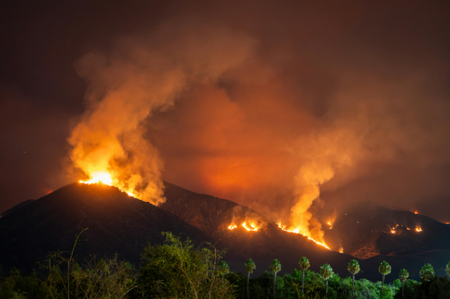
The Eaton Fire, a brush fire in Eaton Canyon in the Altadena–Pasadena region, was originally reported to have burned 20 acres (8.1 hectares; 0.031 sq mi; 0.081 km2) shortly after January 7 at 6:15 p.m. PST. Residents near the canyon reported to emergency services that a nearby electrical tower was on fire, according to Pasadena Now. The fire had spread to a minimum of 200 acres (81 hectares; 0.31 sq mi; 0.81 km2) at 7:12 p.m.
The fire will continue to spread quickly due to the winds, according to Los Angeles County Fire Captain Sheila Kelliher. The Eaton Fire expanded to 1,000 acres (400 ha; 1.6 sq mi; 4.0 km2) in under six hours. 95 senior adults were evacuated from the Terraces at Park Marino; pictures show that several of them were in wheelchairs and were simply dressed in gowns. Later, evacuations were extended to Pasadena, Arcadia, and the northern Sierra Madre. Several homes and the AltaMed Medical Center were "engulfed in flames" in Hastings Ranch. The fire had spread to 10,600 acres (4,300 ha; 16.6 sq mi; 43 km2) at 10:36 a.m. PST on January 8.
The fire started to spread into Pasadena's residential areas at noon. The evacuation of La Cañada Flintridge was ordered. The fire had claimed the lives of at least five persons. The Eaton Fire started to move toward Mount Wilson on the afternoon of January 9. As of January 18, the fire was 65% contained, and 17 people had been killed. On 22 January, Eaton was said to be 95% contained.
HURST FIRE
At 10:10 p.m. PST on January 7, the LAFD issued an immediate evacuation order for all areas north of the Foothill Freeway between Roxford Street and the Golden State Freeway–Antelope Valley Freeway split due to the "rapid rate of spread" of the Hurst Fire, a 50-acre (20 ha; 0.078 sq mi; 0.20 km2) brushfire in northern Sylmar.
The California Department of Forestry and Fire Protection (CAL FIRE) stated that the fire had spread to 500 acres (200 ha; 0.78 sq mi; 2.0 km2) at 1:47 a.m. on January 8. The Hurst Fire had expanded to 855 acres (346 hectares; 1.336 sq mi; 3.46 km2) by 9:40 p.m. PST that evening.
According to CAL FIRE, the Hurst Fire was 10% contained by 3:56 p.m. on January 9. The containment efforts more than tripled, reaching 37 percent containment by 8:19 p.m. Seventy percent of the fire was contained the next day. On January 16, around 10:30 a.m. PST, the fire was 98 percent contained. After destroying 799 acres of land, the fire was completely contained that same day.
KENNETH FIRE
The Kenneth Fire was initially reported to have started along a trailhead close to Victory Boulevard in the West Hills district of Los Angeles on January 9 at 2:30 p.m. PST. 50 acres (20 ha; 0.078 sq mi; 0.20 km2) of fire rapidly spread. Both Ventura County and Los Angeles County resources were sought. The area from County Lane Road east to Valley Circle Boulevard and Vanowen Street south to Burbank Boulevard was under mandatory evacuation orders.
Additional evacuation alerts were issued for portions of Oak Park and areas east of Valley Circle. The fire had spread to at least 960 acres (390 hectares; 1.50 sq mi; 3.9 km2) by 5:30 p.m. PST and was getting close to the Calabasas and Hidden Hills communities. Shortly thereafter, Newsom declared that 900 more firemen would be sent to the region.
Investigations are underway to determine the cause of the fire. The LAPD nabbed a man who was stopped by civilians who thought he was attempting to create a fire. In the end, police determined that they lacked sufficient cause to hold him on suspicion of arson. The fire burned 1,052 acres (426 hectares; 1.644 sq mi; 4.26 km2) of land before it was completely extinguished on January 12.
Almost 10 million people in the Los Angeles area received a wireless emergency alert message on their cellphones on January 10 after an evacuation notice was mistakenly issued for the entire county rather than just a portion of it due to the Kenneth fire;
A follow-up correction alert was sent after County Supervisor Janice Hahn subsequently acknowledged that the alerts were unintentional. In favor of the California Governor's Office of Emergency Services (Cal OES), Los Angeles County suspended the usage of Genasys on January 10.
HUGHES FIRE
On January 22, just before 11:00 a.m. PST, the Hughes Fire was initially reported in northern Los Angeles County, east of Castaic Lake. By 12:30 p.m., the wildfire had spread to over 3,400 acres and was completely uncontained, forcing residents of Castaic and other nearby villages to evacuate. The fire was 36% controlled as of January 23.