
Air pollution and irresponsible development works call forth the destruction
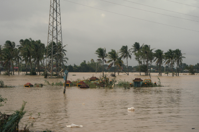
In the weeks of August and September, approximately 90 people had died and thousands had become homeless following the incessant rains and thundershowers which had resulted into the most destructive flooding and landslides across the north India, which had not been seen in the past few decades. The Himalayan states and territories such as, Uttarakhand, Himachal Pradesh, Jammu and Kashmir and Punjab were affected in the worst possible ways. Owing to the unstoppable rains, the river Yamuna had crossed it's danger level which had flooded the entire Delhi, prompting the administration to move thousands of civilians to shelters.
Unimaginable losses in Punjab's cultivation
The farmers of Punjab, the official agricultural hub of India and the residence for 30 million people, had stated that their crops and livestock s were all destroyed. By the middle of September, 43 people had lost their lives and 1.71 lakh hectares of crops were destroyed. Union Agricultural Minister, Shivraj Singh Chauhan had submitted the detailed report on the flood situation in Punjab to the Prime Minister, Mr. Narendra Modi after making the observation of Punjab. According to the statement of the farmer of the worst hit Kapurthala district, Surinder Singh, his 10 acres of farmland were inundated since 11th of August, "We have lost paddy, maize and wheat crops worth rupees 7 lakh. Children had to be moved to safer villages. The government visits, but we have received little help, so far." In between August and September, 1600-1900 villages had become inundated in Punjab.
A highway between New Delhi and Gurgaon had been out of operation for eight hours following the submerged condition owing to heavy rain. According to officials, this year's rain had crossed the level of Punjab's average annual rainfall. "We have moved to these tents for now as our homes have been submerged in water. This is just like the 2023 floods," told the 55 year old Rekha Chaturvedi of the Nigambodh Ghat area. The 70 year old farmer from the outskirts of Jammu and Kashmir, Fayaz Ahmed said, "This is the second time this month our fields have been flooded. We saw extreme heat this year and now water keeps entering our homes and farms after just few days of rain. Something has changed. It was never like this in my youth."
Suicide prevention helpline rings constantly in Marathwada
Two weeks of non - stop torrential rain had flooded Marathwada, usually a low rainfall area. 16 seasonal tributaries and almost hundred water tanks got overflowed and washed away crops, houses and cattles. In the drought prone district of Dharashiv, a village became inundated in three days continuous rain. The village river, Banganga, whose sands the local sand mafias had stolen, couldn't hold the rainwater and overflowed the village, destroyed the crops, houses and food stock and killed 300 cattles. The vast scenario was so gripping that through a farmer's viewpoint, the catastrophe seemed like the end of the world.
The affected farmers were constantly seeking assistance by calling the suicide - prevention helpline in Marathwada. A large section of proletariat did not have any idea about how to tackle the rapidly changing whims of nature. Farmers were regularly committing suicide. But the states were not announcing the numbers of the dead. But the government was only focused on winning the upcoming elections next year. The monsoon of 2024 had shown an omen for the coming years. At present the helpless people would have to cope up with the aftermath of this devastation.
The severe change in climate plays the key role
According to the experts, the change of order in climate had played a pivotal role behind this abnormal rain, started from August. The South Asian countries, the most densely populated parts of the world which had been exposed to weather's wrath owing to it's global warming, should have taken precautionary measures against the rapid increase of these deadly rains. In Uttarakhand's Dharali, the geologist and campaigner Navin Juyal's cautionary words that no concretisation would be enough to save Uttarakhand from the Kheer Ganga's ravages, once any upstream activities excited the Bhagirathi tributaries, turned out to be true in August. On 5th August, incessant rains upstream had started a terrible flooding of water, mud and boulder into Dharali that happened to be a pilgrim's halt on the way to Gangotri. The flood had engulfed hotels, homes and vehicles. The actual number of deaths happened to be much more than the official number of 7. Few days later, houses and cowsheds in Rudraprayag, Chamoli and Uttarakhand were inundated by a cloudburst rain. Before that, in July, after few glacial lakes became overflown, many hydropower dams were damaged and a bridge connecting Nepal and China was completely destroyed. From the beginning of 2025 Summer monsoon, 36 cloudbursts, 74 flash floods and 70 landslides were recorded in Himachal Pradesh by the concerned authorities. Weather studies by Indian Meteorological Department had shown that such weather extremities had been happening frequently. In 2024, there were 473 "extreme heavy rainfall", in 2023 the number of which was 421, in 2022 it was 296 and in 2021 it was 273.
The high altitude situations having steep slopes all around had turned Himachal Pradesh and Uttarakhand more vulnerable to the flash floods. Two years ago, researchers at Lawrence Berkeley National Laboratory found that global warming had turned snowfall into rainfall in northern hemisphere. With every 1 degree rise in average temperature, the rainfall was increasing by 15% in high altitude areas.
Irresponsible development works
According to scientists and campaigners like Juyal, destructions in Uttarakhand and Himachal Pradesh were not called forth by cloudburst rain. The unplanned and irresponsible road development works across these vulnerable mountainous regions had also created this havoc. Juyal and other weather activists had requested to the Union Surface Transport Ministry for five years at a stretch to widen the 885 km Chardham Highway for making visits to Yamunotri, Gangotri , Kedarnath and Badrinath much easier in all seasons, "Faulty and unscientific widening of the highway has increased the risks of landslides," told Hemant Dhyani, an environmental activist and a member of the High Powered Committee (HPC), that the Supreme Court had established in the August of 2019, to thoroughly evaluate the Chardham project. Dhyani explained, the contractors involved in this widening project used to cut the trees and dump them on mountain sides. They would also stock the excavated materials of the project in such a way that had weakened the mountain slopes making them more susceptible to deluge and landslides. The HPC members had suggested the "Cut and Fill" strategy which included cutting the little portion of the mountain, while filling up the valley's sides. "The Cut and Fill strategy minimises tampering with the mountains and can only be done if the road width is restricted to 5.5 metres," said Dhyani. But the authorities, in most of the places of the Chardham project had widened it upto 10 metres that the filling method of the mountainous regions couldn't withstood. At Sidho - Kanho - Birsa University, Purulia, the consequences of that approach were written in the research paper published by Soumik Saha and Biswajit Bera. In the research paper, 811 landslides that had started since the widening of the Chardham Highway were mentioned. The researchers mentioned in the Geotechnical and Geological Engineering terms, that most of the landslides, increased at a rapid pace between 2013 and 2023 had taken place on the mountainous steep slopes. "The widening project has effectively turned long segments of the Chardham route into chronic
landslide zones," said Mallika Bhanot, a volunteer for Ganga Abahan Citizens Forum, at present campaigning for sustainable development.
Multifaceted destructions by humans
According to the weather experts, the climate changes that human blunders have caused strengthened the South Asian monsoons during June to September and October to December. Monsoon has become almost unpredictable with unexpected cloudbursts dumping abnormal amount of water. Then unusual dry spells follow. "We are living in a warmer world. Nearly 1.5 degrees hotter than previous - industrial time. The intensity and frequency of such extreme rainfall events will only increase. This is the new normal. Natural drainage systems have been destroyed. Rivers are mismanaged. When intense rainfall coincides with such vulnerabilities, disasters like these become inevitable," said Anjali Prakash, professor at Indian School of Business, Hyderabad and the writer of several United Nations Climate Reports. She also believes that speedy expansion of cosmopolitan areas, destruction of forests and unplanned infrastructure together has made the flood conditions worse. At United Kingdom's University of Reading, the Meteorologist, Akshay Deoras says, severe rain can occur owing to the local weather condition and larger weather conditions. But presently, this climate change is making these weather conditions more intense. For more than a decade, Akshay has been tracking the Indian weather system, "If the rainfall is uniformly distributed, you will not get that much of an impact. But if that rainfall happens, let’s say, in a couple of hours or even, for example, an entire month's rainfall happens in a few days, that is just going to create problems. And that's exactly what we are seeing." According to the climate specialists, careful planning and rebuilding in climate - sensitive areas should install early warning systems, consider multiple risks, make local communities prepared for facing disasters and finally get the relocation infrastructure ready. As per the data of Emergency Events Database, prepared and preserved by Belgium's University of Louvain, only in 2024, Asia has been through 167 climate disasters, the maximum of all other continents, during which the entire continent has incurred loses up to $32 billion. Storms, floods, heat waves and earthquakes; together all these were responsible for this loss. At this point, especially, the South Asian countries must deliberate upon policies to tackle these onslaughts, because the frequency of these natural calamities will only increase more and more, Deoras says, "Right now in India, there is no clear vision, as to how things could be handled in the future."
How Uttarakhand is being destroyed
On November 9 of 2000 the entire nation had seen the birth of a new state, Uttarakhand. At it's hour of birth it was hoped that the people of Uttarakhand would be much benefited culturally and geographically by their governing bodies as those politicians also happened to be the son of the soil. But owing to the curse of the successive ruling regime that didn't happen. First Congress, then BJP, had deprived the common people of their much deserved benefits. To divert people's attention elsewhere from the issue of development, BJP finally had drowned the collective consciousness of the state in absolute darkness by intoxicating them with the public opium of Hindutva. People had forgotten to raise their voice. To make things worse, their administration started advocating for illegal and detrimental development works. Roads were designed poorly; dams were wrongly planned along with several huge wrongly executed construction projects were sponsored in the name of state development which had scientifically proven totally destructive for a mountainous state like Uttarakhand. More so, that even after producing all the scientific evidences to the Supreme Court about the damaging consequences of the Char Dham highway construction, the apex court had given green signal to the project.
The natural losses Uttarakhand incurred
Since 2000, in the course of constructing highways, dams, mines and government townships, the state had lost almost 50000 hectares of thick natural forest. If one hectare of forest had 3000 trees, then 150 million trees had been destroyed in these development works, the environmental and economic cost of these losses would always remain irreparable. The common people were not benefited in any way by these development works.
The Himalayan range situated in a seismic zone and covered with dense forests which was not only a necessary support system for indigenous communities' livelihood, but also played a vital role in to prevent disasters like soil erosion and landslides. So it was highly irresponsible decision to concretise this vulnerable geographical setup which had called forth several natural disasters including the recent calamities of Dharali. The irony was that, the responsible bodies behind these disasters claimed or addressed these as natural disasters, whereas in truth every single disaster in the Himalayan region has been man - made disaster. The dangerous outcomes of the poisonous network of politicians - contractors - bureaucrats. The bureaucrats went on sanctioning the illegal projects and development plans for their leaders' financial interests, of which they also received a considerable chunk. As a result, the naturally vulnerable geographical setup and its environment became more vulnerable unleashing untimely and abnormal cloudbursts that triggered landslides and floods wiping out settlement after settlement of ordinary people.
On top of the bed of the Bindal and Rispana rivers in Dehradun, two highways, both 10 kilometres long are being built, lately. The objective is to make it easier for the passengers to travel smoothly to Mussoorie from Dehradun. According to the latest information, the planning and executions of these estimated Rs.6000 crore rupees projects are full of faulty features. The drilling works will destroy several legally constructed buildings and other premises on it's way. Besides, the drilling will bring forth severe soil erosion and the pillars, those are being constructed to support the unnecessary highways, within the river bodies obstructing the natural flow of river water, will cause flash floods. Recently a citizens' group says in their statement, the people of Dehradun "strongly feel that this mega project, with huge expenditure of several thousands of crores and the disruption of public life, will directly benefit those who always profit from government contracts and indirectly profit the manufacturers and dealers of cars. The entire project plan is still wrapped in secrecy, although the identification of the houses to be demolished for this project has already begun." Dehradun's resident architect, Bharti Jain writes, millions of cubic metres of soil are about to be excavated from the beds of Bindal and Rispana. Now, if those huge amount of soil is "dumped along rivers, beds will rise, increasing flood risk. If concreted, seepage into aquifers will be blocked. These rivers are not just seasonal drains; they are the veins that recharge our ground water. By obstructing them, we risk floods in the monsoon and droughts in the summer. Dehradun already faces falling ground water levels. RBEC (Rispana Bindal Elevated Corridor) may give us a temporary traffic bypass, but it will take away something far more precious - our water security and ecological balance. We the residents of this valley must decide: do we want short term relief at the cost of long term survival?"
A latest survey among the residents of Dehradun has revealed their strong dismay at the construction of these highways. Like the simultaneously constructed Delhi - Dehradun highway, these two highways are being planned to help only the tourists to reach Mussoorie quickly. The local people's beneficial factors are not being considered at all. In comparison to the ecological and social prices that are going to cost in the long run, the initial short term benefits of the local people will be meaningless. The beneficial points for the tourists are also not clear yet. Once the highways will open, thousands of extra cars and buses will enter Dehradun. Controlling this extra traffic will become a problem as this will create another form of traffic jams. Is the Uttarakhand government planning to construct ten storeys parking zones in the mountain areas to accommodate this huge number of automobiles? Of late, following the uncontrollable heavy downpour, the houses, roads, bridges, shops were washed away. Bindal and Rispana are flowing surpassing the danger level. Hopefully the concerned authorities will reconsider these disturbing highway plans. Shekhar Pathak, the man with the maximum knowledge about Uttarakhand than any other person says, instead of making tourism respectful of natural setup and the local communities like pilgrimage, the government is prone to turn it aggressive and destructive. Schools and hospitals need to be established that the local people will be able to afford. Thus the government will have to ensure an overall sustainable economic future for the people of Uttarakhand, to whom the administration owe this.
Court in weather - protection
This is becoming more and more reality that cases related to weather - protection will get more importance in court.
In 2007, a 9 year old girl Ridhima Pandey had made an appeal in the National Green Tribunal. She said in her appeal, the government's inaction in obeying the conditions of the international treaties regarding the prevention of climate change, was robbing children of her age of their fundamental right to live. Overruling her appeal, the Green Tribunal said, in the 1986 Climate Protection Law, the features of 2015 Paris Treaties were present. But the Supreme Court had delivered different verdict. In the beginning of 2025, the Apex Court had passed this order that court would have to keep constant vigil on the co-ordination of the cabinet ministries, regarding the implementation of the weather policies. The inaction in case of protecting the climate change was being viewed not only as the administrative laxity, but also as the breach of the constitution.
The Indian weather related cases have been through four decades. This current change in the Supreme Court's outlook is the upshot of that long process. Beginning with the protection of Ganga to air pollution to the prevention of the industrial waste discharge - these public interest litigations (PIL), has left the weather - protection not only on the whims of the government, but has also turned it into the responsibility of the law.
In 2024, the Supreme Court's verdict in the case "M. K. Ranjit Singh Vs. The Government of India" had made this transformation clear. The Apex Court had proclaimed that, to save themselves from the detrimental effects of climate change was not only the people's right, but also their right to equality.
In the last July, an opinion of the United Nations' International Court of Justice had made this position of the Supreme Court much stronger. The International Court had expressed this opinion, the countries whose carbon emission levels were the highest; they would have to take measures to control their government and private manufacturing industries. This decision of the International Court and the Supreme Court of India's opinion - these two together can use the power of law to prevent the climate change. After that, there was the maximum chance that the number of weather related cases in India would increase.
After receiving the verdict of the International Court of Justice, our judges will now deliver their verdict in favour of the petitioners in maximum cases. The Indian courts, on the basis of the international laws and the constitution can compel the government to answer. Thus, the government bureaucrats will get minimum chances to act arbitrarily in implementing the climate policy. If they delay unnecessarily, if they don't function enough, they will come under the pressure of law. Those who are being affected the most by the climate change - the cosmopolitan residents affected by the city pollution, the endangered villagers following deforestation, the residents of eroding coastlines - their hope of getting redressal will become stronger. Because, now the courts can put pressure in implementing the administrative practices relating to the climate protection. They can give instructions in the co-operation between different ministries. At the time of approving an industrial project they can make the survey regarding it's effects on surrounding climate, mandatory.
India runs more risks in climate changes, since it is the largest carbon emissions country. Severe heat waves and horrific floods are reality now. Perhaps, coming under court's pressure, the government will be compelled to pass more stringent law. That may be a comprehensive law for climate protection or pollution control or transparency in taking a decision. But by changing the law and order, will the government be able to control those establishments who instead of valuing the long lasting benefit and permanent development pay more important to instant profit. Although court's interference is powerful, still it has to work within the limits of democratic legitimacy. Court may be the driving force; still the long term change depends on judicial reformation, the power of the leaders and the level of participation from the affected people. In case of climate protection, India's biggest obstruction is the conflict between financial development and environmental preservation. Beginning from coal mine up to steel plant, India's industrial structure is strongly dependent on carbon. A sea of people's livelihood is related to these industries. On one side, the legal obligation to environmental protection and on the other side the pressure of employment and growth. The conflict can be solved through fair transformation. It is not easy to transform the industries that destroy nature, into green technology. Court's verdict can speed up this transformation. But this processing needs well thought - over policies and well-coordinated venture. The diplomatic complications and the conflicts between the vested interests of different parties create obstructions for the coordination, most of the time. The supervision of the judiciary department can order the government departments to work together. But for the practical implementation of the same, political willfulness and administrative efficiency are needed. As long as we are not changing the definition of development, as long as we are not considering the environmental protection as the center point of our economy, the court's verdict shall remain confined within black and white.
Natural Calamity will increase, claims research paper
Flood had ravaged Punjab. One after another farm land, houses, and cowsheds were washed away in rampant flash floods. Several villages had been obliterated by flash floods in Uttarakhand and Himachal Pradesh. Lately Kolkata had experienced her share of cloudburst rain. In time of it's grand festival, Durga Puja, the city's commerce and industry had incurred huge losses. But not only India, of late, Europe had also experienced severe heat wave and untimely wild fires had ravaged large portion of America. On these emerging circumstances, a research paper had been published in Nature Dot Com magazine. It was clearly mentioned in that paper that, in future, these natural calamities would take more dangerous proportions and those would occur more frequently. Interestingly, a person's age and in which portion of the planet that person was living, would be the deciding factors about what kind of natural calamities the person would be facing. In the research paper, a comparative study between two times frames had been carried out - one, the recent past, that is 1991 - 2000. Another, the near future, 2021- 2050. Several inequalities had been observed in the comparative study between the population statistics and the weather forecasts. Side by side, this had also been explained, how warm current and cold current out of confrontation between them were creating heavy rain in someplace and drought in other place. The science of wealth study called it, "compound climate extremes".
The dissimilarities that have come into the observation are, worldwide, there will be an increase in flood at some places and drought in other places as a result of abnormal heat waves. The most affected will be Asia and Africa whose children and the youth section will be in great danger. The "compound climate extremes" is rapidly increasing in the surrounding areas of the Sahara desert due to rapid increase in population. In Europe, North America and Australia, the old people will be the most affected by the mixed effect of heat waves and heavy rainfall. As the result, there will be great anxiety regarding the health system and social care system. In warm countries, the severity of winter will be lessened. But in some portions of America, North Europe and the east Asian countries, the severity of cold wave will increase. As a result, there will be dual crisis surrounding heat waves on one side and long lasting cold waves on the other. The research study claims, the population explosion in the developing countries is responsible for these climate disasters up to a great extent. But in some portions of Europe and Asia, where population increase is either less or decreasing, the climate change is solely responsible for these natural calamities.
The glaciers are melting in Kashmir !
The environmentalists are worried about the glaciers in Kashmir. In a recent report, released by the World Meteorological Organisation (WMO), in between 2023-2024, the overall weight of the glaciers, spread across Asia's high mountain ranges, have decreased. Kashmir also falls in those territories. The report has claimed that reduced snowfall and increased heat during Summer are the reasons behind this weather change in Kashmir. For the last two years, several regions across Kashmir are falling prey to severe heat waves. Infact, the entire India along with Kashmir has greatly suffered from the 2024's Summer heat. According to the weather specialists, this unnatural heat is destroying those glaciers. Several small streams and small rivers in Kashmir have dried up already. The Kolahoi glacier in Anantnag runs the maximum risk of getting melted. This glacier, known as "The Ganga of Kashmir" happens to be the source of many surrounding water bodies and their continuous water supply. Although in past decades, this glacier's size has decreased in an alarming proportion. The environmentalists are also worried about the Thagious glacier of Sonmarg, popular among the tourists. If this way the glaciers continue to melt, the overall livelihood will be affected in Kashmir. A large number of Kashmiri people are connected to agriculture and farming. Their lives can be harmed, by the continuous destruction of environment. People are falling sick every now and then from these heat waves which are much hotter than Kashmir's normal Summer temperature. The hydrologist Mushtaq Pir says, "Without the immediate interference, it's effects on environment can be highly dangerous."
If stagnant water doesn't get any channel to flow out, disasters will take place
Heavy rainfalls had occurred in West Bengal many times before. This is natural according to the laws of nature. Approximately 300 millimeter rainfall is also not unnatural. The question is, every time there is heavy rainfall why does that result into horrible disasters? There's only one answer to this question - because of the human's misdeeds and harmful acts.
In the 4th October of 1968, there was devastating flood in Jalpaiguri, West Bengal. After that, in 1993, a cataclysmic rain had resulted in a deadly flood in the Dooars of West Bengal. That flood had changed the geographical setup of the central and eastern Dooars, forever. Was the rainfall in north Bengal on the night of 4th October, this year, more than those above-mentioned rainfalls in their severity? Or we ourselves had invited that deadly disaster in advance? If we don't pay serious attention to this issue right now, we won't get any time to do so later.
What had triggered the natural disasters of North Bengal on the night of 4th October?
A rainfall near about 300 millimeter doesn't mean a natural disaster, in general. But if that huge amount of rain water doesn't get any channel to flow outside, disasters likely take place. The major rivers of the North Bengal have lost their navigability up to a great extent. The dried up rivers of Dooars are left in pathetic conditions. Slowly the rivers will lose their water carrying abilities. We build buildings and other constructions stopping the natural flows of mountain springs and rivers. We forcefully change the natural course of rivers and absorb their streams for our vested interests. As the obvious result, any natural heavy rainfall flood the plain lands on it's two banks. The obstructed mountain springs in the course of time accumulate tremendous water pressure and then come crushing down the mountain taking everything on it's way on the plain land resulting in deadly flash floods. On this year's 4th October night, exactly that had happened in the North Bengal.
We still need to understand some extremely crucial geographical facts. The entire North Bengal's geography is in a vulnerable state, because in terms of nature's time discipline, the Himalayas is still in it's infancy. That means the geographical setup there is highly unstable. At any moment, any geographical change can take place as per the whims of Earth's geological setup.
On a sensitive mountain range like that, our absolutely insensitive act of deforestation and digging the mountain soil surface up to a harmful proportion had made the geography of the region more unstable. Last few days' incessant rainfall had made the soil wetter. Naturally the wet, unstable soil couldn't hold the pressure of that huge rainwater. And that water came down the mountain slope taking down tremendous amount of soil, rocks and boulders on it's way on the plain land below. A great amount of human lives and livestock were lost. The bridge on the Doodhiya River came crashing down following the monstrous water pressure on it's foundation pillars. Previously it was noticed that people were building houses and other illegal constructions almost on that river. But the local administration didn't take any action. That's why we ourselves had invited this disaster.
The weather cycle is changing rapidly across the world. Kolkata itself hasn't witnessed these kinds of serialised heavy rainfalls in the past years. These kinds of rainfalls will occur in the coming days. Even some are going to be more severe than this. And then, we will not be able to get away only by blaming the nature. We'll have to pay the price. So, in order to avoid these pathetic outcomes, we'll have to return the previous soil tolerance to the geology of North Bengal and simultaneously we'll have to preserve the soil resilience of that area. We'll have to take all the necessary measures to bring back the navigability of the North Bengal's rivers. Otherwise, we have no way out.
How socio - economic conditions make people vulnerable to natural calamities
Flash flood came down the hill in the Mahananda River. It was quite natural on that fateful day, because of the random deforestation; the humus lair in the soil which usually soaked and absorbed the rain water got completely washed away in the river. As a result, the flood plains of the river were destroyed and the river couldn't hold the water pressures of the flash floods and the huge water along with the boulders and soot had flooded the area. So nature couldn't be blamed for this. Because ultimately we were responsible for this.
In the Himalayan range, landslide was very normal. Like any other natural blow this was also normal at the unstable mountain range. Heavy shower, even torrential rain was very normal here in Autumn. But under no circumstances, a day's shower could lead to a natural disaster of that proportion. A careful insight would tell the other story. This danger was approaching step by step for a long time. It had become inevitable.
For the last three decades, throughout the Himalayan range, on one side as deforestation had increased, on the other side, road constructions and human settlements had increased at a rapid pace, without any tested infrastructure. What were small settlements consisting of few wooden houses, had become unending rows of very weakly constructed two to three storied concrete buildings, built on the edge of the mountain slopes . And these constructions were for the purpose of homestay business. But the edges of the mountain roads built usually on the sloping ground could break loose every now and then. But people didn't care. Hunger was such a strong motivator. The general job prospects on Himalayan terrain had almost come to nothing over the years, resulting into people's increasing dependency on tourism related economic activities. And in doing so they had even risked their lives. The administration knowing all these didn't pose any impediment, the obvious reasons for which were clear. That's why; a natural disaster on a mountain range had claimed so many lives.
In Jaldapara forest range, the rows of floating animal dead bodies had pointed to the dangerous level of deforestation, taken place in that forest range. Only a thick forest range could save an entire place from that kind of disaster. Because the old huge mountain trees would have hold the soil so tight that in spite of a torrential downpour the chances of soil erosion would have stopped. Lest the flash floods. In the end, all these innocent animal lives would have been saved. Several parts of the No.10 national highway staying under deluge were not anything new in that area. The reason for strong protest against erecting the dam on the Teesta River, at Kalijhora near Sebak was, because of the dam, the alluvial soil deposits on the river bed would overflow the river during the rainy times. And that would increase the danger level of that landslide prone area. The huge water at the confluence of Teesta and Rangeet rivers were facing the blockade at Kalijhora dam for a long time and a huge amount of water had gathered in that confluence. So the kind of flash floods the people had experienced in that area could have been much worse. It had been observed that unfortunately the affected grass root level used to stay on the river bank and at close proximity to the landslide prone areas.
With alluvium on it's bed, the illegal sand pits are making the rivers overflow
On 4th October, the record breaking heavy rain and the water coming down from Bhutan were limited within Dooars, Alipurduar and Coochbehar. The water came down from Sikkim into the river Teesta. And the speed of this flow of water was not severe like that of Bhutan. One night, water was released from Gajoldoba barrage. And Teesta couldn't hold that water. Because in 2023, since the banks of the southern Lonak lake broke, the bed of Teesta was filled with alluvium and boulders. Moreover, in parts of Teesta, complaints of illegal excavation of sand and boulders had risen. According to the report of the irrigation department, behind the recent damages and losses there were the destructive activities of six rivers in 150 places. Jaldhaka, Torsha, Shisamara, Dyna, Gathia and Mahananda rivers had become dangerous with the heavy rainwater and the water that came down from Bhutan. Teesta had overflown at a dangerous level. While searching for the reason, the experts had found two reasons. Firstly, the forceful excavation of sand and boulders from the river bed, forcefully turning the river towards another direction and filling up the river in places had forced the river water enter human settlements.
According to local source, from Sebak up to Bangladesh, sands were excavated from Teesta. In the dry season, lorries were filled with excavated sands at Jalpaiguri and Mekhliganj near Teesta Bridge. Paharpur, situated within the adjacent area of Jalpaiguri had become the free zone for sand excavation. The persons under whose supervision the sand excavation went on in that area were known to be closely associated with the ruling party. Besides, from Murti, Ghis, Torsha, Jaldhaka, Raydak, Sangkosh rivers, daily on an average, three lorries of sand used to be excavated from the illegal pits, during the dry season. Such pits were scattered in thousands. The results of all these were dangerous, claimed the experts. Because of these, large holes had formed at someplace and high mounds had formed at some other place in the riverbeds. So, when small amount of extra water had entered the river, it had caused eddies in some place and currents at other places. And that destructive water force had flooded the human settlements on it's two banks. The opposition leader of the state Subhendu Adhikary said, "Sand mafias are changing the directions of all the rivers along with Teesta and they are party members of TMC. The Land Reforms Department is connected with them." An official of that department said, "This is a syndicate. Officers are being transferred all the time. But the syndicate keeps functioning as usual." The minister of state for backward class welfare, Bulu Chikbaraik said, "Be it sand or stone, the government doesn't spare any pit on the riverbeds. Many sand mafias are under BJP's shelter." Amid this tug of wars, a high ranking official of the irrigation department regretted, "Everybody knows where the problems lie. Only the solutions never come."
"We have lost our home. Where shall we light the lamp for Diwali?”
The flash flood had taken away the bamboo walls of the house on it's path. Heaps of alluvium had gathered on the thin concrete floor. Already the inmate of the house went there and cleaned up a portion of the alluvium. Again he paid a visit to the house and lighted one lamp on the broken floor, instead of fourteen. This year the inmate, Kandu Roy had spent Kali Puja and Diwali in the government's relief camp. He along with others had been living on the Jaldhaka damn of Jalpaiguri. The administration had assured them of government housing. Although that would take a lot of time. Until then, how they would spend their days in government camps? Like the urban areas, the houses in their village had also been decorated with lights. Colourful rangolis had been made. But just beside these, on the banks of Teesta and Jaldhaka rivers, darkness that had fallen suddenly, become darker. Sitting under the tarpaulin shade on the Jaldhaka damn, Kandu Roy said, "We are receiving the relief. But river has taken away everything we had. Where we shall stay now? Every day I am visiting my house and removing alluvium. In the day of festival, I'll have to lit at least one candle."
On the banks of Teesta, people were spending their days in relief camps. The residents of Hoglapata area of Dhupguri had to spend their days beside the rail line. For few families of Bamondanga area of Nagrakata, it was not possible to move elsewhere from the relief camps. An air of dismay was hovering in the camps. When the government would deliver the homes? Although the administration had claimed, without the proper survey it was not possible to build homes. According to the administration's report, 14000 houses had remained inundated in Jalpaiguri. But who was the owner of the house, how much damages had occurred, who were entitled to receive the compensation; the actual surveys had not been completed about these facts, claimed the administration. Madhu Roy of Amguri said, "I have heard the government instructions. The administration has also recorded our names. But for how many days, it is possible to spend under polythene? According to our custom, we light fourteen lamps on this day. But the home itself is not there. Where shall we light the lamps?"
Paying post - construction money helps the plans to get passed
"If the houses on the left side had not been so high, you could see the Kanchenjunga", regrets the car driver. The car is climbing up the hill along the Hillcurt Road, towards Darjeeling. After advancing a little, the mountain slopes start disappearing behind concrete houses. The driver again says, "For these houses, the landslides occur." According to the West Bengal municipal rule, it is not permissible to build houses taller than 11.3 meter in the hill area. But across the Himalayas 13-14 meter or taller houses are being built. How? It can be heard that soil is not tested. In most of the cases, plans are not passed before constructions. After finishing the construction, paying money at the right place gets the plans officially passed. In Kurseong, a large portion of the road in Rohini has collapsed. All along beside the road new buildings are being constructed. Car or motorbikes showroom, homestays, restaurants are coming up. A proprietor of one such construction says, "Now customers prefer to stay in these kinds of facilities. That is why I have built this homestay in association with the local residents. We had to spend some in order to secure the permission." Recently, in respect of a case, the Darjeeling municipality has been ordered to demolish forty illegal constructions. Addressing this issue, several residents of Darjeeling say, "If all the illegal constructions are to be demolished, then how many it will come up to, there is no account for that." The ex- chief of Gorkhaland Territorial Administration (GTA), Binay Tamang and Ajay Edward has protested about the scenario, "Is it only building construction? The money that is coming for different development plans of the mountain, how much of that is being used?" Across the hilly terrain, questions are being raised regarding the quality of the road construction works under the Pradhan Mantri Gram Sadak Yojana and other schemes. Under the Rural Infrastructure Development Fund, even the utilisation certificates of the infrastructure of roads, academic institutions and hospitals are not issued. Ajay Edward says, "The center and state want to make the leaders of the ruling parties of the Himalayan range, their toys by giving them access to corruptions.
Although, when Ajay's Hamro Party was in the power at the Darjeeling municipality, then how much active they were in the implementation of the policies, the Himalayan people still raise questions about that. On the condition of anonymity, a section of the residents say, the municipal representatives who used to live ordinary lives as the members of the Hamro Party, are roaming in expensive cars with their associates, after joining Anit Thapa's Prajatantrik Morcha. Dismissing all the accusations, the leader of Prajatantrik Morcha or the GTA spokesperson, Shakti Sharma says, "Tourists are increasing. There are scarcity of lands in the hill regarding building and infrastructure. In case of implementing a project, it has been found that the land belonged to either a tea garden or the forest department. That's why tug of wars is going on regarding which one is legal and which one is illegal." Fingers are being raised at the administration also. In the landslides and flash floods the Tabakoshi village of Mirik has been completely destroyed along with the 37 homestays. A section of the administration has informed, those constructions were built on the tea garden land on the river bank, without adhering to any policy. Who gave those homestay authorities the permission? According to the owner of a homestay, "Everybody knows everything. But something had to be done. Through these the socio-economic conditions of the residents and the area were developing." According to the Jana Andolan Party leader, Harkabahadur Chhetri, behind the Himalayas' present scenario, crores and crores of rupees are being rolled through other means. The car driver says, "Political leader, some administrative officers, contractors - all are busy in making money. They don't care about the mountain's condition."
Hotels and resorts are coming up in every corner in forest area. Some people are looting the forest range
Whenever the water level increased in the river during the rainy season, Jahir Mian had seen big fishes. But after the recent calamities, looking at the Shiltorsa (the local name of Torsa River) river, adjacent to his house, Jahir Mian was surprised. According to the eastern bank resident of the Shilbari ghat in Alipurduar, "For the first time in my life, I have seen rhinos, wild beers, deers are floating in the river. The animals were trying to hold onto the floating logs in the river. Every year, Assam’s Kajiranga, Jahir and his father, Amir Hossain had seen in the news media, several wild beasts were floating away. Their question was, "From now on will those happen in Jaldapara also?" The north Bengal weather experts were not discarding the anxiety as baseless. They had made an appeal that, corruption was behind this. From Dooars to the hills - the allegations of corruption surrounding this entire forest range was nothing new. Throughout the ages, evading the watch of the forest department, deforestation was going on. In place of forests, residential complexes, hotels, restaurants were coming up. Forests were decreasing. But investigation into how the developers were getting the permission for all these brought forth the names of the local politicians to the forefront. Four years ago, in the version of the Chief Minister herself, a TMC leader's name had come forward who was accused of illegally cutting the trees at the Buxa forest. This trend had emptied many portions of the Buxa tiger project. Same complaints had been raised at Jaldapara, Gorumara, Baikunthpur and Mirik. According to the environment activist Arup Guha, "A substitute industry has come up surrounding the forest range. The industry of looting the forest. The worst sufferers becoming the wild animals. Sooner the concerned authorities understand that, better it will be." Another environment activist Shyamaprasad Pandey said, "In jungle or the adjacent eco - sensitive zones, one after another constructions are coming up. I didn't understand how the model village was built at Bamondanga in Jalpaiguri through the government initiative. Because that area was the grazing field of rhinos."
According to the forest department, the robbers send a team of 40-50 men to cut the trees. After selling the woods, the maximum share of profit goes to the big trader. From there, different amount of money are sent to the politicians and the forest department officials, as per the complaints. Those who don't want to remain in these systems, either keep their mouths shut or get transferred. West Bengal's head chief forest ranger, Sandip Sundariyal is on holiday. The forest ranger in charge, Piyar Chanda says, "In the forest, animals are increasing in numbers. Perhaps in tandem with that, forest areas have not increased." The independent minister of state of the forest department, Beerbanha Hansda says, "Since the time, I have come to power, I have been running around. So that everything goes well. At this moment, things are going exactly in that way." The coordinator of the environment organisation, NAF, Animesh Basu cannot keep his faith on the initiatives of the forest department. He says, “The way rhinos and wild animals were seen floating in the Torsa, we're afraid, in the coming days these will be seen repeatedly. Chilapata area's resident, living beside the forest area, Rasikha Rava teases, "In the south Indian movies, they float the trees in the river. Here also trees float. Now the wildlife is also floating."
Community kitchen is closed. The villagers are on their own now.
For Uttarakhand's Dharali village, Diwali went unnoticed. On 5 August almost half of the village was destroyed by flash flood in such a pathetic way that 200 people had lost their lives and 50 buildings, including hotels, restaurants, homestays and houses were destroyed. The entire populace of the village remained so engrossed in mourning for their departed ones that even Diwali couldn't uplift the spirit of the villagers. The villagers only had the distant vision of the illumination and firecrackers of other villages. 50 years old Radha Rawat, whose homestay along with it's tourist inmates were destroyed and killed, said, "We have realised that our pain was only our pain. We cannot make others feel it. They cannot mourn the way a victim of a calamity mourns. We didn't celebrate Diwali. The villagers of adjoining Mukhba, Harshil and Chhomli also observed the day with simplicity. They lit only a few lamps and burst firecrackers. The residents of other villages in the hills or valleys celebrated the festival as usual. We heard that Diwali was organised with much fanfare in Dehradun and other cities." After finding 10 bodies, the rescue operation workers had stopped their operation, as it was impossible to find any more bodies. What the villagers had surmised was that almost 190 bodies had remained buried under greasy mud ranging from 10 to 20 feet high. According to the ex - panchayat chief of Harshil, Dinesh Rawat, "We stand by the people of Dharali. They are in deep pain. They know that their family members are buried under the soil. Their source of income is gone. Some of them had apple orchards which were destroyed. The community kitchen, which was started there with the help of the government, was closed after a few days. The villagers are on their own now." On 5 August, 8 soldiers died when their army camp got swept away in another flash flood. 30 years old Dharali resident, Santosh Joshi lamented, the people of Dharali had expected that the government officials would come to Dharali and ask them about their conditions, "Sixty per cent of Dharali, including the market area, has turned into a ghost village. Businessmen who had opened their hotels and homestays here, are waiting for certain approvals from the government to rebuild their structures, but the residents of Dharali do not have enough to even sustain themselves. The affected families have got Rs.5 lakh from the government, but that is insignificant compared to the scale of tragedy."
In the time of disaster, people need therapy for their mind
When disaster strikes, the affected people's minds become overshadowed by uncertainties, worries and fear. They receive aid but nobody gets to know about their mental distress. The resident of Bamondanga model village in Nagrakata, the 17 year old Rakhee Oraon was sobbing from time to time. While searching for shelter in neck deep water, Rakhee got separated from her mother following a collision with another person. Later, although Rakhee was found, holding onto a bamboo grove, her mother was never found. Like Rakhee, almost 25 boys and girls became victims of this post disaster trauma related to personal loss. The health department had appointed psychiatrists for their counseling. As North Bengal remained devastated from natural calamities, on 10th October the World Mental Health Day was celebrated. The main objective of this occasion was, "The opportunity of getting mental health services during disaster and emergency situations."
Large scale disasters create mental devastation in people of every age and social status. The terror of dying, watching the familiar houses, localities, cultivation lands getting washed away, witnessing the known ones getting killed and lost ; create deep trauma, pain and repentance. Those mental wounds need to be treated. Else, many people carry those wounds for the rest of their lives. A person's every action and decision gets influenced by his traumatized memory. Relief means not only tarpaulin, flattened rice and jaggery. After large scale disasters, psychiatrists showed in their survey, the severity of this mental illness.
After the Latur earthquake in 1993, a survey had shown, among the survivors, 74% were suffering from "post-traumatic stress disorder", 28% were suffering from panic disorder, out of 10, 9 people were suffering from major depression. One year after the super cyclone of Orissa in 1999, out of 10, 4 youngsters were suffering from some kind of disorder. These had been witnessed after every big disaster.
In Kochbihar's Baro Athero Kota village, a refugee woman said to a volunteer, "The river has swallowed my home and my sleep. Still now I cannot sleep at night while listening to the sound of river current." In India's Disaster Management Act, 2005 and National Disaster Management Guidelines, there's a mention of "Psychological Support", but in reality there is no implementation of the same. National Mental Health Programme is mostly city - based and it's budget is also limited. There is no plan for taking mental care and providing mental health services at the time of disaster. The subject of this year's World Mental Health Day is pointing towards that - who is actually distressed? Who are the affected? What is their relief? Since health means mental health also, then at the time of disaster, why no arrangement is made for mental health services? Not only doctors, we also need the specially trained mental health workers who usually work among people. During relief work, they need to stay with the rescue workers. Sending a counselor for one week after disaster is not enough. Post disaster, the mental health of the affected people should not be considered as the last preference or soft issue. Any kind of disaster makes the inequalities more naked. The poor, Dalit - Adivasi, specially challenged persons always fall to the last stage of any disaster relief work. A proper attention to mental health will rectify this problem of inequality. Else, healing the wounds of disaster will remain incomplete.
The long term negligence that paves the way to the North Bengal's disaster
Those who live on the banks of Teesta, loose their homes and belongings in flood, once every year. Those people have been made to accept this as part of their lives. But who have made them accept this kind of a miserable life as normal? To search this answer, how far the people of North Bengal will run back in time - to the post - freedom India? To the 34 years rule under the left front? Or to this present TMC regime? It is written in almost every textbook of the West Bengal education board, that North Bengal is the flood - afflicted and malaria - prone area. Still, since independence, why no solution has been planned for the North Bengal's flood problem?
In 2023, the excavation at Sikkim's Lonak Lake had begun the perils for Teesta. The huge water flow had broken a vast portion of the Himalayas and flooded the prairie. The army camp was also flooded. Immediately after, the central irrigation department, the central weather bureau and the central water planning department had begun their survey about the Teesta problem. All the departments' survey had informed that Teesta's riverbed had risen owing to the alluvium deposit. As a result, any mediocre disaster would cause huge losses in the coming days. Exactly that had happened. This year on the day before Laxmi puja, no flood water had descended from Sikkim. Only heavy rainfall occurred. As a result, one day water had been released from the Gajoldoba barrage. In effect Teesta's banks had been overflown and thousands of houses were swept away. After that Teesta survey, the dredging was planned on Teesta, for which 600 crore rupees budget was set. It was also planned that private organisations would take care of the dredging and the government wouldn't have to spend a dime. For decades after decades, this was being mentioned in the survey reports that not only Teesta; the riverbed of Mahananda, Jaldhaka, Torsa, Raydak, Daina and all other small and medium size rivers that flew down from the hills, had been risen due to the alluvium deposit. These rivers were also included in the dredging list along with Teesta. Inspite of all these, the dredging project had not progressed.
In the end of 1960s and the beginning of 1970s a plan was taken for Teesta - The Teesta irrigation plan. Although, supplying water to cultivation lands through canals from Teesta was the primary objective of the plan, but the main objective was river linkage. It was planned to link Teesta with the river Atreyee through a canal. As a result, the farm lands of North Bengal would receive sufficient water and the flood problem would be solved. The project was divided into three sections and each section was divided into three sub - sections. Each sub - section was also divided into three sub - sub - sections. Long wait followed by center - state tug of wars had finally announced the project, rejected! The flood continued as usual.
The obvious question rises - had the 5 August calamities happened in Kolkata or it's adjacent areas instead of North Bengal, would the administration sit hand in hand? Or the well planned project would have been implemented to control the flood?
How north Bengal's geography was systematically destroyed
The history of north Bengal is like a game of foundation and destruction. Under the British rule, north Bengal's administrative boundary was resilient. But the main objective of this administrative restlessness was stealing the assets. In 1865, Darjeeling was included within the British India. In that year, the Dooars was also included within the British India through the Sinchula agreement. In 1866, Kalimpong was taken from Bhutan. These imperialistic steps had formed the basis of the frontier warfares and administrative weaknesses. In 1869 Jalpaiguri district was established. In that same year, the construction of the famous Hillcurt Road from Siliguri to Darjeeling and in 1881, the establishment of the Darjeeling Himalayan Railway (DHR) was milestones of development and also marked the beginning of the destruction of the north Bengal's nature. Especially in Darjeeling and Dooars, the British had started uncontrolled administration. The worst affected was the Land Rule. The general rule of the Bengal presidency, that was the Permanent Settlement, was not applicable here. Using this judicial absence, the planters had used their Westland Rules and thus, denied the Janjati tribe's right on their lands, mercilessly cut off the forests and set up the tea gardens. Darjeeling was a dense forest area before it came under the British rule. The main objective of the British was to export tea and wood. The establishment of any manufacturing industry was not in their thought. Those lootings of natural assets and judicial weakness are responsible for today's north Bengal's scarcity of lands and environmental vulnerability.
The mountain range of north Bengal happens to be the vulnerable geography of the eastern Himalayas. This young mountain range is made of soft stones, full of crevices. As a result, a little bit of extra water level makes the geography landslide prone. Owing to the high level seismic activity, this area runs the risks of big earthquakes.
The temperature is increasing in the Himalayan range. The Teesta damn and hydroelectric projects have become dangerous. The defects in the Teesta 3 and Teesta 5 hydroelectric dams had increased the dangers of 2023 flood many times more. Scientists have identified this catastrophe as one of the fiercest floods in the history of Himalayas. The cutting of the mountain up to Sikkim in order to build the Sikkim - Rangpo railway service is creating huge pressure on the subterranean structure of the still young Himalayan range. The tunnel excavation is creating deformity in soft stone structures. Huge damn building and tunnel excavation have increased the risks of water body - initiated earthquake. Nature is not taking revenge now. Rather humans have welcomed that revenge.
Since the time of imperialism, the tea garden labours are still deprived of their rights to land ownership. Now as the West Bengal government is planning to use 30% of the tea garden areas for other purpose, the threats for these people to become homeless is becoming stronger. This deprivation and the absence of lawful land ownership make the rehabilitation more difficult during the natural disasters. After the last disaster, it has become difficult to determine the rehabilitation package for the inhabitants of Banogram, because they don't have the lawful right to land. According to the affected people of Mirik, living in relief camps, they have lost same house thrice in landslides. Now they desperately want a secured home. Siliguri Municipal Corporation’s Climate Resilient City Action Plan is an important model. In 2018, as the first city of India, Siliguri had taken up this plan. Under this plan, taking 2015-2016 as the basis, it has been decided that every year, 14.6% greenhouse gas emissions will be decreased. Since Siliguri happens to be the gateway to the Terrai region, the successful implementation of this model can be a fruitful example for the Climate Change Action Plan of the Dooars and the hills.
Few steps need to be taken at this hour. First, after identifying water bodies and greeneries, the rule of the correct use of land has to be maintained. On the hill, all the houses higher than 11 meters and the illegal homestays will have to be demolished. Second, construction of new barrage on the Teesta has to be closed and an impartial and scientific examination has to be carried out on the risks and environmental effects of the existing barrages. The geological stability needs to be examined by an independent specialist while withholding the construction of new rail route temporarily. Looting of the rivers will have to be controlled strictly. Third, the land registration deeds have to be distributed among the tea garden workers and the inhabitants of Banogram.
But the most important thing is to hand over authoritative power to the hill people. For this the demand for the amendment of Gorkhaland Territorial Administration under the sixth schedule of the constitution needs to be considered. The sixth schedule gives the autonomous territorial administration the power to make the rules on land registration, forest administration and social cultures. This works as the original constitutional weapon to protect the illegal utilisation of environment. Through their constitutional empowerment the independent community will be able to face the risk of climate change and overcome the history of land ownership deprivation. Which means, to save the north Bengal we need a public movement?
Removing illegal possession or maintaining navigability? Kolkata Corporation in a dilemma over canal restoration
In 2025 Kolkata became flooded following tremendous rain before Durga Puja. In the background was the incapacity of the canals to carry the pressure of the excess water. This year to avoid that kind of a disaster, the irrigation department has already started inspecting the conditions of the canals in and around Kolkata. The irrigation department has confessed that the slums erected alongside the canals pose a great issue for this disaster. Complains are being raised for a long time that these slum dwellers have captured even the main body of canals and have been throwing away their garbages in the canal water for decades, resulting in the loss of canals' navigability. Recently on the side of the Eastern Metropolitan Bypass, the dredging of the alluvial soil has begun in the DD1 (East) canal. For years encroachers have been staying in the shanties made on the canal body. Now after demolishing those shanties the dredging work has begun.
But the irrigation department could not show the courage to drive away the settlements alongside that canal. Owing to the resistance of the encroachers the department couldn't bring down the JCB machine in the canal. Later the machine had to be floated for 1200 meter along a different direction towards this canal. The political fraternity was seeing the vote politics within this hazard. In the heavy downpour of last year, the surroundings of this canal were flooded. The irrigation department was in talks with the Kolkata Corporation regarding the establishment of few pump houses in and around Kolkata.
Are the major Indian deltas sinking? Special emphasis on Kolkata!
According to a latest study, the Ganges, Brahmaputra, Brahmani and Mahanadi deltas have been sinking faster than the speed at which the sea level has been rising. In Kolkata, the land mass has been subsiding much faster than the regional average speed about the same. The assessment that has been made covering 40 delta regions of the world specifically mentioned 3 delta regions out of 19 in all over eastern India. The assessment told these 3 delta regions where unscientific ground water extraction has caused those land subsidence, already have affected 90% of the entire delta area. Scientists have warned of chances of massive flooding owing to this land subsidence and advised immediate beginning of ground water management along with the necessity of a stable infrastructure.
In the major 13 deltas of the world, including Yellow river in China, the river Nile in Egypt, Mekong river in south east Asia, the river Po in Italy and Brahmani, Godavari, Mahanadi in India, land masses have been subsiding even faster than the yearly 4 mm global sea level rise. Robert Nicholis, a climate scientist at the University of East Anglia of the UK who also co - wrote the research paper said, "The dominance of subsidence over sea - level rise is striking. In every delta that we monitored, at least some portion is sinking faster than the sea surface is rising." With other coastal cities like Alexandria (the Nile delta), Bangkok (Chao Phraya), Jakarta (Ciliwung) and Dongying (Yellow River), Kolkata has also been identified by the study, published on 14 January in Nature magazine, to be witnessing land subsidence. In a media release, the study's lead author, Leonard Ohenhen, in the University of California, Irvine, said, "If land is sinking faster than the sea is rising, investments in ground water management, sediment restoration and resilient infrastructure become the most immediate and effective ways to reduce the exposure (risks)." Scientists have noticed in their analysis that the danger of land subsidence is becoming more dominant over the dreadful sea level rise. So for the millions of coastal residents, the main fear lied in their lands going down.
This study echoes the result of another 2023 independent study that had shown that Kolkata had witnessed land subsidence ranging between 4 mm to 12 mm between 2003 and 2011. In the study, according to the satellite pictures, subsidence zone had been identified in the west bank of Hooghly River by the geophysicist Bhagwan Chowdhury and associates of the Kurukshetra University. They had clearly said that the ground water level in that area was going down. Chowdhury had warned, "But we also noticed some encouraging signals - aggressive and large - scale recharge of ground water can help slow down the land subsidence." His study had already witnessed subsidence decrease between 2017 and 2021 ranging between 2 mm to 3 mm in the areas where large scale groundwater recharge measures were taken. Chowdhury had also pointed out, the high rises in Kolkata would be in danger of facing severe damages as the result of this land subsidence, "This may require revision of building design codes," he said.
India's large growth projects become vulnerable to climate disasters
According to the report titled, 'Climate Risk and Insurance for India's Infrastructure ', prepared by the Delhi based organisation, Climate Trends, growth projects worth RS. 2.95 lakh crores were under the constant risk of various climate disasters. Ironically this report was released almost at the end of the World Economic Forum at Davos, where the Indian leaders had depicted India as the emerging third largest economy of the world and a right destination for making further investments. The report pointed out that climate risks in India were out - growing India's ability to insure the large infrastructure projects like mountain highways, hydropower projects and city area developments, making the government and big investors vulnerable to huge financial worries. The director of Climate Trends and a co - author of the project report, Aarti Khosla said, "....India's Infrastructure push may be expanding climate exposure faster than risk - transfer mechanisms are adapting. As India seeks big investments at the World Economic Forum and plans double digit growth over the next five years, it would be remiss to not point out the risks to Indian infrastructure posed by climate impact and extreme weather events - which are unarguably increasing in frequency, severity and geographical spread." Another project researcher said, "We have prepared the report based on our ground level findings, including feedback received from several leading insurance companies of the country, like SBI General Insurance, Munich Re India, Swiss Re India and General Insurance Corporation of India. ...... flooding, extreme rainfall, cyclone and landslides..... as high to very high risks for capital intensive infrastructure such as urban assets, highways, ports and hydropower projects, driving repeated losses and rising insurability concerns."
India was ranked as the seventh most exposed land to the worst kind of natural disasters. Taking that into consideration, the leading global insurance firm, Swiss Re said, ".... India's life and non - life insurance premiums will grow at one of the fastest rates in the world through to 2028 at 6.7 per cent and 8.3 per cent respectively. The project report further said, "These (vulnerable projects) range from Orissa's Paradip Port modernization project to Rs.5000 crore worth of port projects in Andhra Pradesh, tunnels and highways worth RS. 38000 crores in Himachal Pradesh, Teesta hydropower project in Sikkim, Zoji - la tunnel and BRO road projects in Ladakh, to Arunachal Pradesh's Etalin, Dibang and many other dam, highways and hydropower projects." Aniruddha Bhattacharya who led the project report preparation told, "Investing in new infrastructure is essential to driving growth. However, the heightened climate vulnerability needs detailed discourse, especially on the risks to the capital expenditure heavy undertakings in the eastern sections of the country." According to the Delhi based think tank, Center For Science and Environment, between January and November of 2025, on more than 99% days of a year, India went through severe climate disasters.
The story of looting Damodar's river bed
It is hard to recognise the wintry river during the monsoon. In Winter looking at the quiet river with the low water level, it becomes hard to imagine what kind of an aggressive swelling river it becomes following three month's incessant rainfall during the rainy season. In 1932, the Anderson barrage was built in Ranadiha of Sona Mukhi. The objective was to control the flood. Still today, water overflows from one side of the low barrage. In the three months rain, pointed gourd and ground nut cultivations have incurred losses on both banks of Damodar. In this area the water of Damodar barrage cannot be used for cultivation. The water coming through the shallow and submersible pumps are only used for cultivation. All around the paddy field makes it green up to the horizon. In the mid - monsoon, due to overcast sky, the grain is not caught in the rice straw. Whenever the barrage authority releases water, both sides of Damodar get flooded. As humans depend on river, the river also tries to keep the balance in human's life. The losses in the pointed gourd and ground nut cultivations have cast a shadow of financial difficulty on several farmer families. They know this will hamper the potato cultivation during the coming Winter. In the farmland at a distance, a tractor is running. Few days ago that piece of land was flooded with flood water. Still now there is water. Several places in former river bed have been filled with soil and turned into farmlands. As a result, the two sides of Damodar get flooded with regular tides.
In Barojora near Durgapur, there is another barrage on Damodar. A canal from here flows towards Sonamukhi. Burdwan gets the water of Damodar. After Barojora, there is Pakhonna, then Kuldanga. After crossing Kuldanga one can see the row of yellow hills across the horizon. Those are made of sands excavated from sand quarries of Damodar. Sand, stone and coal quarries or mines have become regular news nowadays. According to the Indian constitution, the river sand is the public asset. But after the formation of these sand quarries, the people cannot use even the minimum amount of sands either for building their houses or for other purposes.
Whereas according to the 2021 New Sand Mine Policy of Bengal, in order to maintain a river's health and it's natural flow, all the responsibilities of excavating sands had been given to the State Mineral Development and Trading Corporation. As the result of this, excavating sands from the river beds should have been stopped. Previously this particular operation was in the hands of a private body. The sands on the river banks used to be auctioned. Several small auctioneers without properly investing in the machines, used to excavate sands. Small lease holders wanted to keep the transport expenses low. As a result, huge amount of sands and stones used to be excavated from river banks. The risks of the destruction of river banks used to remain high. States wouldn't receive enough revenues and rivers used to be damaged. According to the new policy post 2021, it was decided that the "Excavation Division" of corporation would excavate sands and the "Storage Division” would store them. The "Enforcement Division" would supervise on the process. By excavating sands from river beds, the chances of the destruction of the river banks would lessen. According to the sizes of the mines, different controlling systems would be implemented. The entire system would be controlled from a central government website. The electronic challans of sand transportation would be issued from that website.
Still, how much sand can be ultimately lifted from river beds, probably there is no measurement about that. In the last August, the Supreme Court's verdict in the Jammu and Kashmir related case is that only after taking into consideration a river's sand re - creating capacity, sand could be lifted from it. For sand excavation, securing the environmental licence is mandatory, that means a legal district survey report is needed. In the central government's 2020 sand excavation instructions it has been said, immeasurable and illegal sand mining harm a river's health. So, sand can only be lifted according to a river's capacity of re - creating it's sand.
This law is being flouted everywhere. Not only in Bengal, but throughout India, rivers are being looted. Everyone is busy calculating the profit margins in this illegal sand business. Nobody is worried about rivers' sand re - creation capacity. Narmada, Tapee, Godavari, Kasai, Damodar and even Bolpur's small river, Kopai are being plundered this way. The people of Midnapore lament saying so much sands have been lifted from Kopai that there is nothing left on it's bed except clay - soil. Before starting the excavation, the law of securing the environmental licence by making the district survey report does not exist in Bengal. Whereas the Supreme Court's order is applicable to the entire country. But in 2021, has the centralised control system in the hands of central corporation produced any good results? In the policy it is mentioned that the corporation can appoint agents in the excavation and transportation of sand. Does the mystery lie there? Do the states receive the exact amount of royalty per truck that they are supposed to receive? How far the money, that are not reaching the government exchequer, going to? Are truly the illegal mines being closed? In the legal mines, is the government controlling according to it's new policy? Recently central investigation agency has noticed the mine owners' unaccounted income. People are being arrested. Has the administration woken up suddenly? Or are the two political oppositions busy in tug of war, inorder to acquire the revenue for the coming assembly election purpose?
Recently, after the horrible cloudbursts and flash floods in North Bengal, the details of the destruction of rivers by illegal sand mining have come forward. In Darjeeling, Jalpaiguri, Alipurduar and Kochbihar, there are 500 sand mines on the rivers. In the 2020 "South Asia Network of Rivers, Damns and People" report, it has been mentioned that immeasurable sands and stones are lifted from Mahananda, Mechi, Chenga, Rokti and Balason rivers. Perhaps now as the life has become normal again, these questions will become distant. A river wants to create the circle of life in it's own environment - friendly way. But do we love the river?
Illegal sand mining along Yamuna
Responding to a petition to carry out an investigation in the illegal sand mining along the Yamuna River near the Uttar Pradesh and Delhi border, the National Green Tribunal (NGT) had noticed serious violations of environmental laws. Officials from mining department and pollution control authorities had formed a joint committee which had submitted it's report in the early December, 2025. The report had mentioned several incidents of illegal sand mining outside the lease area by a company, Nirmal Sand and Infra Private Limited. The company had also flouted the rules, formed to control the increasing air pollution of Delhi. This company dealt with construction business and sand mining. The joint committee had noticed that even during the Stage III of the Graded Response Action Plan (GRAP) that was in motion in Delhi to close the mining and associated activities, the company carried out it's sand mining illegally. According to the report, there had been instream mining in the active river channel. Also unauthorised ramps were constructed in the river bed and excavation was carried out to a depth of 15 - 20 feet in the river bed. The NGT had given four weeks to all those concerned authorities to submit their responses to the petition. The matter was listed on March 17 by the NGT. It was found that Nirmal Sand and Infra Private Limited were mining 110 meters beyond the lease boundary in the Yamuna mid-stream. The report said, "And this area falls in the middle of the riverbed of the Yamuna River, Google Earth image reflected that the Respondent No. 9 (company) is executing mining activity approximately 110 meters towards the mainstream of the Yamuna River." According to the report, the company records didn't have environmental audits and six - monthly compliance reports. The joint committee had informed the NGT that the company neither had planted any trees in the project area, nor did they have established any septic tank to collect the sewage from the toilet.
Bombay stands at the threshold of death parade due to rainfall
Although the other name of water is 'life', but the inhabitants of a seaside town like Bombay and the other cities where they confront incessant rains every year during the rainy season, will say, that to them water means death, in a way. A group of researchers from the Chicago and Princeton University, after making a comparative study between the Bombay municipality's statistics of death by other reasons and statistics of death by rain has informed that every year, almost 2500 people die directly from rainfall and it's other direct and indirect causes. The kind of observations they have made in their article, published in the Nature magazine, makes the situation worrisome. In the past ten years, the number of persons, died from rain related causes in Bombay was much more than the persons died of cancer in Bombay. It is being observed that after a heavy rainfall, for the next five weeks the number of deaths remain the highest. Children less than five years old, die at the maximum number due to rainfall. Adult women die more than adult men in this case. And 80% of these deaths take place in the ghetto areas of Bombay. The scenario these statistics draw is not only true in case of Bombay, rather all the cities of India and the world, directly or indirectly affected by weather catastrophe, are bound to admit these statistics. Especially in India, the administration has this escapist tendency to bypass the responsibilities of the rain caused disasters by addressing them as 'annual events' that solely lie in the hands of nature and destiny. Rain and heavy rainfall are definitely nature related incidents. But to confront that disaster the city's municipality infrastructure and drainage systems will also have to remain prepared. Avoiding the deaths of citizens either from drowning in the rainwater or from rainwater related electrocution or from other related incidents, as just accidents that deserve only an one time ex-gratia amount of money, cannot be accepted. It has already become clear that the municipality's failure and inefficiency are responsible for the heavy death toll from heavy rainfall. The situations the researchers have shown need to be analysed from health related issues as well as the issues of socio - economic and financial disparities. No administration can deny the hard reality about the lack of municipality structure's development, the violation of citizens right and human rights that stand behind the maximum death of ghetto area people, especially women and children due to heavy rainfall.
Indian administrators do not like the foreign researchers and their research works. Whereas the administration can educate them by studying these works, because the particular steps of administration that can stop this death ride, there are hints related to that in those research papers also. At the root of it, two chains should be broken. One is heavy downpour and the issue of stagnant water / flood. Second, the death of citizens from the flood water and stagnant water. The development of the drainage system can break the first chain. And a correct weather forecast system, the ever ready healthcare system to confront the natural disaster related diseases and epidemics. If truly these developments can be done, then not a single person will die from the electrocution in stagnant rain water or from coming into contact with hidden wire under the stagnant rain water. Also the number of deaths from dengue, diarrhoea, malaria and typhoid will decrease. Where citizens' lives are concerned, the administration's indifference and procrastination are unpardonable offences.
An honest endeavour to control flood
Few days ago, research groups from Manchester University of UK, Hokkaido University of Japan and Aliah University of Kolkata joined together to deliberate upon the natural methods to control flood in south Bengal's Shilabati river basin. The researchers carried out series of workshops in IIT Kharagpur and Aliah University in Kolkata. Then they went on reconnaissance trip to the maximum flood - prone Ghatal and it's surrounding areas in West Midnapore district in West Bengal. Owing to the ravages of four floods every year, the people of Ghatal and it's surrounding areas have granted waterlogging as a painful part of their daily life. The helpless people use bridges, constructed across boats and unsteady bamboo footbridges during floods. Many houses are built on stilts for the sake of the inmates' survival. People in tribal villages like Iswarpur and Alui, cultivate potatoes in the silt covered land after floods. The assistant professor of geography department at Aliah University, Aznarul Islam said, "The root cause of floods here is a severe form of soil erosion - called gully erosion - at the Gangani badlands upstream. That leads to a flow of sediment in the lower part of the basin." Gangani is called the Grand Canyon of Bengal, where in the passage of time, Shilabati River has carved deep ravines, caves and cliffs. The researchers have realised that river embankment and dredging may not be of help here as top - down solutions. Rather, Joe Ravetz of the University of Manchester advised the authority of this project to take ideas from the natural strategies that were used for flood management in UK's Mersey river basin. To prevent soil erosion on that river bank, ponds were created, natural channels were cleared of obstructions and wide area grass plantations were made.
According to the researchers, through tree and bamboo plantation and creating vegetation, the abnormal water flows in the primary channels that cause the flood in Ghatal during the peak of monsoon, can be prevented. They also suggest that this excess water can be channelised in ponds for using in the Summer. Or in a planned way the water can be left and let the ground soak it. This will raise the ground water level. Mehebub Sahana of the University of Manchester has said, instead of top - down process, people - centric process that means community - developed techniques should be used to control floods.
Hard water
Until few days ago, what was abundant in this world, has become a rare and much sought - after commodity - that is water. The name of the United Nations' recently released report is Global Water Bankruptcy. In different cities of the world, frequently tremendous water crisis are being created. People run errand for a bucket of water. Besides, everybody knows how cultivation suffers due to drought. The UN report says, the water crisis is not the same everywhere. Somewhere the water crisis has already become tremendous; somewhere the crisis still waits in the future. But the report has made it clear that the ongoing crisis of an area is the premonition of that same danger in other places. Because the whole world is connected with different threads - business, migration. When the cultivation of a place gets affected by drought, it's effect reaches distant places in the form of food supply shortages. Similarly when excessive rain triggered flood affects the life of a place, other places bear the brunt of that catastrophe in the form of migration from that affected place. The report has reminded us, that as drought is a manifestation of water crisis, excessive rain and flood are also another forms of water crisis.
Drought and flood, both are the two different depictions of the same problem - the changing patterns of rain. The destructive climate changes have also created disturbances in rain cycles. After a long drought, heavy rainfall creates flood, because the rain water is not getting the time to penetrate the soil. The ground water level deficit is not getting filled up. On the other hand, the character of glacier meltdown has also changed. As a result, the water flow of mountain rivers has become irregular. Snowfall cycle is also being disturbed. At present, a scarcity of sufficient snowfall is being noticed in the states near the Himalayan range. It doesn't mean that there won't be snowfall in those places at the end of winter. It will happen, perhaps even more than the usual. But the character of that late winter snowfall is different - that will melt quickly, so the soil won't get enough time to absorb that water inside. The collective results of all these irregularities will be one - a huge gap between the necessity of water and the supply of the same. In this situation, the water policy will have to be reviewed. Apart from arranging for water reserves in the human settlements and increasing water supply in agriculture, something more will have to be done. More prompt and advanced techniques have to be used to reserve rain water. More researches are needed to increase the water absorption capacity of soil. In the bigger arena, we'll have to turn rainfall and water crisis into an inseparable part of the international weather diplomacy.
We didn't learn anything from our past mistakes, say Green experts
The Green experts maintained that in spite of experiencing all the previous landslides and earthquakes throughout the Himalayas, the people there didn't learn anything from their sufferings. 33 people had lost their lives in the 5 October deluge. Out of them 11 persons had died in Mirik alone. Thousands and thousands of people were reeling under the brunt of landslides and earthquakes. In 2009, 27 people had died in Darjeeling from the onslaught of cyclone, Aaila. Jaswant Singh, the MP from Darjeeling had strongly demanded to the central government for the establishment of a landslide research center in Darjeeling which would study landslides. Citing this emergency, Jaswant wrote a letter to Bijay Krishna Handik, the former minister of mine and development of north - eastern region, "Establishing a center in Darjeeling would be an appropriate choice." The centre still had remained a dream. The ex - MLA of Darjeeling and the Darjeeling chair, Amar Singh Rai had requested for the West Bengal government's initiative to establish a Doppler Wealth Radar (DWR) Station and automatic weather stations in all the major cities of India, "A DWR would be to give more precise warnings on the quickly changing mountain weather and enable accurate NOWCASTs. The early warning would go a long way in saving lives," he wrote. NOWCASTs happen to be extremely valuable weather forecasts for a very short time span. Praful Rao, the retired Wing Commander, and the founder of the disaster management organisation, Save The Hills, had supported Amar Singh's point of view, "The DWR system would give early warnings and this would be extremely helpful for news casting in the fast - changing mountain system." According to Praful Rao, almost 8 to 10 years ago, the Indian Meteorological Department had decided to set up a DWR in the North Bengal, especially in Sikkim. But "no one followed up the proposal," said he. The weather experts denied holding the government solely responsible for the disasters. "Have we citizens acted responsibly?" asked an expert.
The Darjeeling - Sikkim region is situated closely to the convergence of the Indian and the Eurasian tectonic plates. Darjeeling falls under the seismic zone IV, which makes this area earthquake - sensitive. According to an architect, "Despite this, both the government and the residents bury their heads like ostrich on this issue. High - rises come up unabated in the Darjeeling hills. Neither is the government concerned about stopping high - rises, nor does the public fear the outcome of this violation."
Where is our responsibility?
Natural calamities in north Bengal are never unexpected. In ISRO's Landslide Atlas of India, Darjeeling with it's vulnerable geology holds one of the top positions in the list. The earlier documents along with the chronological statements of the families show, since the British period, landslides have been taking place in Darjeeling at every alternate 15 years. For the last four decades, this time span has been decreasing. The veterans of the area also remind the horrible flood of 1968 along with many terrible cloudbursts triggered downpour of the 20th century. Across the Dooars, the incidents of flash floods are characteristics of the rivers of that area. Following 10-12 centimeters of rain, the rivers usually overflow. An overall change at a large scale is taking place across the Himalayas. Mandi, Kulu, Manali, Chamba and North Bengal have fallen prey to cloudburst rain this year. Since all of these affected places happen to be famous tourist spots, the tourism industry has incurred huge financial losses. Himachal Pradesh alone is facing the loss of Rs.700 crores. And since flood destroys alluvial soil layers of the agricultural lands, the loss in agriculture has to be considered as well. Summing up the tourism loss and the agricultural loss, Himachal Pradesh is about to incur more losses in the coming days. For the last decade, these losses have been increasing, especially in Nepal, Bhutan and India. North India has failed miserably in making adjustments with the ever changing Himalayas. In September, the Supreme Court in a suo motu case, has ordered Himachal Pradesh government to study and understand it's geological and environmental changes and submit it's short - term and long - term plans within October.
The Apex Court has put stress on the ultimate truth behind these natural calamities. That is, these calamities are not only nature's whims, rather man-made up to a large extent. Maybe entirely. So immediately the man and nature relationship needs to be reviewed and changed in a new light. Huge number of people inhabits the Himalayan terrain. Not only the mountain region, but this entire area has had given birth and nurtured an array of mountain cultures, which need to survive too. For it's complicated geological structures, the Himalayas has been the most risky among all other fold - mountain range in the world. This is why after any natural calamity, it becomes extremely difficult to supply food and water to the stranded and affected people in the epicenter. But at the time of government and private development works, these points are not kept in mind. Haphazardly the development works are planned and executed. Only the collective awareness of Himalayas' indigenous communities can jolt back the government into reality and make the administration realise what kind of dire mistakes they have been making all these times. This awareness and voice of the mountain people will make us realise that besides the purpose of hill tourism, we have lot of serious responsibilities towards our loving Himalayas.