
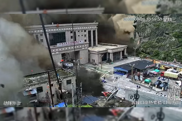
In August 2026, the neighbouring country of Nepal had to face one of the worst calamities ever because of the devastating flooding in Nepal's Bhotekoshi-Trishuli River, claiming more than 350 lives. The actual place of the calamity was the northeastern district of Rasuwa in Nepal. Though the exact reasons for this heartrending mishap are under scrutiny by scientists, “the Satellite analysis points to a massive collapse of glacier ice and rock in Tibet, which temporarily obstructed the river before releasing a destructive surge downstream. The landslide was so intense it was initially thought to be an earthquake. By the time it reached the China-Nepal border, the cascading debris reportedly resembled a tsunami of mud.1 In this context, the views of Austin Lord, Senior Fellow at Simson Centre, a U.S-based non-profit think tank, are worth quoting; he expressed them in an interview with Nikhil Ghanekar in The Indian Express. He said, "The present consensus is that the initial trigger was a glacial detachment that included bedrock on the northern slopes of Langtang Lirung, a 7,000-plus-metre peak in the Langtang range. The exact triggering process is not entirely understood. That could be related to climate-related risks or gradual shifts at the site. Preliminary analysis indicates there may have been some minor movement of the glacial mass in the weeks or months before the event, followed by a tipping point.” He further explains, "Once it failed, it swept down through a gully toward the Lhende River, which reaches the Chinese border. The source area was around 5,200 metres, so the flow descended a couple of thousand metres. It deposited a mixture of ice, rock and sediment, creating a temporary natural dam that blocked the river. The dam failed and sent a major pulse of water downstream. The event reached the China border in roughly nine minutes. The border facility was at a confluence with another tributary, the Gyirong River. The flow then continued downstream. Within seconds of hitting the Chinese facility, it was already moving back into Nepal. There was no realistic opportunity for people at the facility to warn communities downstream; many of those who could have generated an alert were themselves swept away.”2 The description presented here appears to be very near the truth. Here, it may be noted that before the Rasua event, no heavy rainfall incident was recorded in the area. Thus, this disastrous incident does not belong to the routine category of heavy rainfall-cum-landslides etc., which have culminated in heavy loss of life in our country in the past. Then in what category can this Nepal tragedy be placed? Probably, the answer lies here: “The Rasuwa floods were more than an extreme weather event. They were real-time manifestations of a polycrisis, in which global warming, climate pressures, biodiversity decline, water insecurity, infrastructure vulnerabilities, social inequalities and governance failures interacted in complex ways. Rebuilding must account for these interconnected risks to create greater resilience.”3
The Imminent Threat to the Himalayan Region
Climate change is destabilising the Himalayan ecosystem. Nepal-like incidents have previously occurred in India. The following list is indicative of the fragile ecosystem of the Himalayan ranges and the potential areas of threat-
Kedarnath, 2013
In June 2013, Uttarakhand had an unusually high amount of rainfall, leading to the melting of the Chorabari glacier and the Mandakini River overflowing. The disastrous impact of the floods was witnessed in large parts of Uttarakhand, Himachal Pradesh and Western Nepal, causing massive flash floods and landslides. In its aftermath, nearly 6,000 people were presumed dead. Kedarnath was a GLOF (Glacial Lake Outburst Flood) event, the result of a breach in a glacial lake.
Chamoli, 2021
In Chamoli district of Uttarakhand, a large glacier broke away and resulted in a flood, leading to surging waters in the Rishiganga River. Over 200 people were reported dead.
Sikkim, 2023
This horrific incident took place when a glacial lake (large bodies of water that sit in front of, on top of, or beneath a melting glacier) situated in northwest Sikkim at 5,000 metres burst due to incessant rains. It resulted in the release of water in downstream areas and the deaths of at least 55 people.
Dharali, 2025
This is a region in Uttarakhand which is situated at 6,900 metres above mean sea level. The terrain, combined with continuous rain for so many days, triggered mudslides, debris slides and flash floods. In the ensuing mishap, at least 69 people were reported dead.
Explaining the recurrence of similar events in the Himalayan region, Farooq Azam, an Associate Professor at IIT Indore and head of the Cryosphere group at Kathmandu-based The International Centre for Integrated Mountain Development (ICIMOD), a major research organisation working on the Himalayas, opines that “the reason these events in the Himalayan region become so risky is that while they start as individual events-extreme rainfall or landslide or lake overflow-they soon transform into a multi-hazard disaster, involving multiple landslides, flooding and building collapse episodes.” He further says, “The Himalayan region is very fragile. Such events lead to chain reactions. A surging river with large rocks and ice blocks would erode the banks and slopes, and more soil, mud and rocks would become part of the raging river. It becomes a cascading disaster because the waters do not have any other way to spread out. That is why any such event in the Himalayan ecosystem becomes extremely dangerous.”4
The Preventive Measures Need to be Taken
Monitoring every glacier and every mountainside that could collapse is not practically possible. There lies the importance of remote sensing and satellite-based analysis, but different satellite tools answer different questions. Thus, it becomes important to engage local communities. In the span of the past ten years, over a dozen extreme events in the Himalayan region have occurred, and almost all came from unknown places, except the South Lhonak GLOF, which was a known risk. One should not forget that ‘the Himalayas have their own context and significant data scarcity and data sparsity.’5
Remote sensing and satellite imagery form part of the triangle. The second part is fixed station networks-hydromet and seismic stations. The third is localised monitoring.6
It is imperative that local governments, disaster managers and Community Disaster Management Committees be effectively engaged, which can be helpful inthe collection of local data, reporting landslides and monitoring impacts after storms.7
The people who are immersed in these environments can be roped in. These include Yak herders and fishermen, who are expected to notice changes in rivers, glaciers and glacial lakes. Oral histories with elders can also reveal smaller avalanches, glacial-lake floods and other events that science has not recorded, helping identify potential hotspots.8
The mapping exercise to monitor glacial lakes and hazards is of utmost importance. In this regard, such an exercise is being conducted by India's Home Ministry and space agencies.9
The countries of the region must work together to develop cross-border mechanisms for information-sharing, monitoring and regulating infrastructure development in fair, transparent and sustainable ways. ‘This is critical to effectively addressing -and learning to live with-the cascading risks confronting the Himalayas.’10
Climate change is destabilising the Himalayan ecosystem. Therefore, the rebuilding effort must be directed towards mitigating, limiting and reducing the destabilising impacts of climate change, while also reducing human activities. In this context, AI can strengthen resilience and adaptation, particularly through robust early-warning systems.11
The installation of early warning systems, preparing appropriate evacuation plans, and strictly monitoring and regulating construction and other activities in the ecologically fragile region are extremely important steps which must be taken in earnest so that further instability is avoided.
Conclusion
The occurrence of natural calamities in the Himalayan region is not a new phenomenon. But in the last two decades, climate change and global warming have definitely aggravated the devastating effects of such calamities. In the Himalayan region, new factors such as ‘'hanging glaciers' and GLOF (glacial lake outburst flood) have drawn the attention of environmentalists and policy-makers alike. In the changed circumstances, more vigilance is needed at all levels. The installation of early warning systems and other scientific devices, along with the use of AI, are a few necessary steps that are urgently required. Besides that, inter-governmental cooperation in regard to the exchange of relevant information and data is the need of the hour. The most important thing is that the respective governments should give it top priority because any change in the existing Himalayan ecosystem will spell doom for the people living in the plains. Its environmental cost is beyond imagination. This is high time to make suitable policies and implement them with utmost vigour to save humanity from the scourge of climate change and other related disastrous phenomena.
References
- Himalaya needs a shared early-warning system, Editorial, The Indian Express, Aug 28, 2026.
- Austin Lord, Why risk-monitoring in the Himalayas is like looking for 'needles in haystacks', The Indian Express, Sep 2, 2026.
- The Himalayas Need A New Blueprint, Editorial, The Economic Times, Sep 2, 2026.
- Amitabh Sinha, Echoes of past, warning for future, The Indian Express, Aug. 28, 2026.
- Austin Lord, Why risk-monitoring in the Himalayas is like looking for ‘needles in haystacks', The Indian Express, Sep.2, 2026.
- Ibid.
- Ibid.
- Ibid.
- Ibid.
- Editorial, The Economic Times, Sep. 2, 2026.
- Ibid.
. . .