
The construction in the sea that links India and Sri Lanka, known as Adam's Bridge or Rama Setu, has been the subject of discussion for the past many years. The Rama Setu is one of the prime proofs of the holy epic of Ramayana being a series of truly occurring events which has taken place more than seven thousand years ago and is a part of Indian history, hence in this article we will study facts and details regarding this amazing structure which is unique and example of our architectural brilliance.
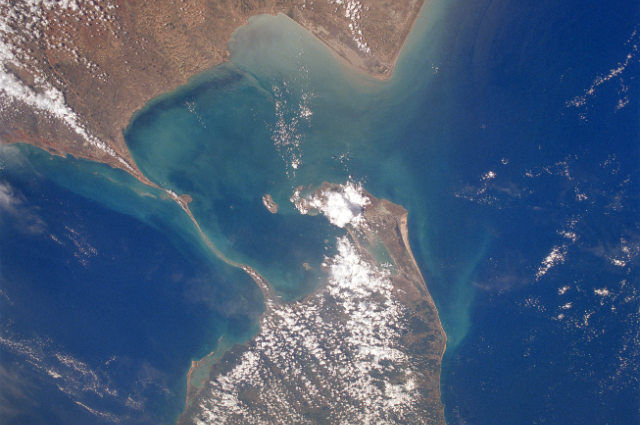
The Rama setu connects the Mannar Island, which is located off the northwest coast of Sri Lanka, and Pamban Island, also known as Rameswaram Island, which is located off the southeast coast of Tamil Nadu, India. According to geological evidence, the bridge used to connect India and Sri Lanka on land. Geographical research and evidence show that the bridge originates as a series of shoals from the Pamban Island in India's Dhanushkodi tip. It concludes on Mannar Island in Sri Lanka.
Now, let's understand and find out the bridge construction according to the ancient beliefs and books.
The Ramayana states that Rama and his Vanara crew attempted three times to build a bridge that would connect them to Lanka. The initial effort is known as Adi Setu, followed by Madhya Setu in the second try and Nala Setu in the third. For hundreds of years this Nala setu has been known as Rama Setu, which is very sacred for Hindus. There are thorough lines in the Ramayana that describe how the bridge was built. The methods that Rama and his Vanara army used to build the bridge appear to be identical to those used by contemporary civil engineering and construction firms.
The bridge was primarily known as Nala Setu because it was built by Nala, the biological descendent of renowned architect Vishwakarma and offers his expertise in bridge design and construction. Nala was an integral part of Rama’s Vanara army and took the responsibility of the bridge construction.
Let’s now drive thousands years back and try to understand the mechanism of the bridge construction by the Vanara Army.
The landmasses of Indian and Sri Lanka were connected millions of years ago,where with time they got separated due to tectonic plate movements and hence there are a lot of sea ridges between these two regions and at that time water was shallow in this region. This shallow region helped the Vanara army in the bridge construction.
The first stage of bridge construction was pilling of trees.Following their sea survey and identification of a naturally occurring, undulating outcrop from the seabed, the Vanara, acting on Nala's advice, leveraged the outcrop and piled various tree varieties—some of which were in bloom at the time—atop it to create a wood cushion. Next, they added large boulders, followed by smaller stones, to create a causeway across the sea.
Nala and his Vanara Arma team demonstrated the following civil engineering skills:
- Foundation
- Alignment in Line: A deliberate endeavor on the side of the Vanara team, the bridge's linear alignment was a significant component of the building of Nala Setu.
- Topography: Every civil engineer makes use of the local topography when building a bridge or a dam. The Baryabandhu Bridge in Bangladesh across the Padma River is a prime example.In a similar vein, Nala and Neela used the local topography to build this bridge. They located a straight line of islands and literally "filled in the blanks'' by connecting them with landfills. According to a research conducted on Adam's Bridge by the Space Application Centre in Ahmedabad, the topography surrounding the bridge is “Comprising 103 small patch reefs laying in a linear pattern with reef crest, sand cays and intermittent deep channels”.
- Pore pressure: The Rama Setu site is a prime example of an engineering achievement where the then-current understanding of pore pressure was included into the construction of the bridge.
- Pumice Stone: The top layer of the Rama setu was made of pumice stones. The pumice stones due to its low density, do not sink in water like ordinary rock does. Igneous rock known as pumice stone is created when lava rapidly cools above ground (lava froth). The locations of the small air pockets are readily visible.
Due to millennia of wave action and sedimentation, the bridge has progressively been covered by shoals or sand bars over 7000 years, from 5000 BCE to 2000 CE.
After doing in-depth geological research on the bridge, Dr. S. Badrinarayanan, a geologist and former director of the Geological Survey of India as well as a consultant at the National Institute of Oceanic Technology (NIOT), has the following to say:
“Geological and geophysical studies of Ram Setu reveal the presence of loose marine sand below the coral layer, clearly indicating that the coral layer in the form of boulders are not natural and formed there on their own, but have been transported by somebody and dumped there; thus clearly establishing the fact that Ram Setu is very much man-made in the hoary past.”
Corals typically develop near the sea's surface and on hard rocks where they may get sunlight. It has been discovered that loose sand is present beneath the corals in the Rama Setu.
Therefore, these corals on the Setu could not have developed there naturally, instead, they needed to be brought in from somewhere else and placed there.
Now, we will study some facts which compare texts from Ramayana with modern-day science and facts.
According to the Ramayana text, the bridge had a length of 100 Yojana and a breadth of 10 Yojana when it was built, or a ratio of 10:1.
The bridge that connects Dhanushkodi, India, to Talaimannar, Sri Lanka, measures around 35 km in length and 3.5 km in width. It was created as an accretion on a naturally occurring sea ridge, and both dimensions are in the same ratio of 10:1 as stated in the texts.
The main mystery about Rama Setu was that, whether such a bridge existed or not.
Dr. S.R. Rao is regarded as the pioneer of maritime archaeology in India. He conducted excursions in 1980 and was able to locate the sunken city of Dwaraka off the coast of Saurashtra, India. Dr. Rao mentioned that at the time, a man-made bridge over the seas would have been feasible because, in his words he states,
“This natural rock connecting the Mannar Island with Rameswaram island is now submerged in the sea owing to the rise in sea level during the last 4000 years or Experience the Knowledge of India Rama Setu-A National Monument Page 45 of 96 more, but then, it was perhaps in the Intertidal zone and likely to have been further raised by piling up of rubble to enable Rama’s followers to reach Lanka. We found at Dwaraka, a natural rock that was dressed suitably as a wharf for berthing ships about 5000 years ago. Similarly the natural rock, in Adam’s bridge, connecting Mannar and Rameswaram, must have been used by piling up rubble manually on it, to enable the Vanaras to reach Lanka. For the ancient marine engineers who could build a tidal dock at Lothal in 2300 B.C and modify a ridge for berthing ships at Dwaraka, the piling up of stones on the so-called Adam’s bridge for an army to reach Lanka was an easy task.”
This bridge has its mention in most of the ancient maps and has also been captured in the modern satellite images by NASA.
Another important debate about this bridge is why it is called the Adam’s bridge.
The bridge was initially called as Adhaam’s bridge, because the first Islamic leader of Sri Lanka crossed this bridge on foot to get from India to Lanka, the Muslims of Sri Lanka named it after Aadhaam. As a result, the bridge holds sacred significance for them. Since the word Aadhaam was easy for the Europeans to pronounce and meant "Adam" when they conquered Sri Lanka, the Europeans also started to refer to it as "Adam's Bridge."
Adam's Bridge, also known as Nala Setu or Rama Setu, was created by Nala, a skilled engineer who was educated in those eras' educational systems and had his bridge constructed by the Vanara. It appears to be the only archaeological remnant from Rama's time. Nala and the Vanara lived in the south Indian state of Karnataka, in the town of Khishkinda, which is now known as Hampi.
According to traditional geography, the southern region of India, which stretches from portions of the modern state of Maharashtra on the west to portions of the state of Orissa on the east, is known as Dravida country. It is located on the southern side of the Vindhya mountain ranges.
As a result, Nala and the Vanara were the first Dravida or Adi Dravida, having lived in the Dravida homeland.
The southern part of India, from parts of the present-day state of Maharashtra on the west to parts of the state of Orissa on the east, is referred to as Dravida land in traditional geography. It is situated on the Vindhya mountain range's southern flank.
Because they had lived in the Dravida homeland, Nala and the Vanara were the first Dravida or Adi Dravida. Historians in the scientific modern world regard the Aryan invasion theory as refuted. Thus, the Rama Setu or Nala Setu represents an achievement in Adi Dravida engineering. The Dravidian Vanara Army made it for their Aryan leader, Rama.
Throughout history, Rama Setu has been discussed as a protected monument in literature. The literature on the bridge's construction and the discoveries uncovered at the Rama Setu site agree. The Setu is thought to be a man-made accumulation over a naturally occurring sea ridge, according to the thorough reports of the scant surveys carried out to date.
This bridge has been described numerous times throughout history, in a variety of contexts and formats, as this article details. These constant allusions offer reliable information on the historical significance of Rama, the bridge's existence, and its historical use.
It is now time for the Archaeological Survey of India to officially recognize this ancient Indian national monument as an archaeological site.
The appropriate next step after this is to designate Rama Setu as a World Heritage Monument.