
Written from the land I call home and inspired by the resilience of Himalayan villages and the slow violence inflicted on Uttarakhand’s ecology in the name of development.
“We were taught to read the slope — where water collects, where stones loosen. Now machines carve faster than we can read.”
—Hema Devi Panwar, 60, lifelong resident, Dharali
“We cut the hills to make our way,
Now every rain has debts to pay.
The land remembers what we ignore,
And home feels fragile, like never before"
When the Land Stops Absorbing Our Mistakes.
I grew up watching the hills breathe mist over the Doon Valley, listening to rain drums against tin roofs, sensing an unspoken balance between earth and sky. That balance no longer exists.
Today, Uttarakhand is a battleground between geological reality and economic impatience, between ecological limits and infrastructure pushed beyond them. What we call “development” in the mountains has increasingly become a trigger, one that magnifies this vulnerability, turning heavy rain into catastrophe and rivers into weapons.
Why Uttarakhand Is Inherently Vulnerable?
Uttarakhand sits on one of the youngest and most fragile mountain systems on Earth. The Himalayas are still rising, fractured by fault lines, steep gradients, loose soil, and unstable slopes.
According to ISRO and Geological Survey data:
- Around 72% of the state is landslide-prone.
- Between 1988 and 2023, Uttarakhand experienced over 12,000 landslides.
- Annual landslide incidents jumped from 216 in 2018 to over 1,100 in 2023, and nearly 2,946 in 2024.
This is the baseline. Against this reality, every road cut, every blast, every tree felled removes a layer of natural protection. Yet construction has expanded as if these mountains were geologically benign.
Hotels, homestays, highways, tunnels, and hydropower projects have proliferated often without adequate geotechnical studies, drainage planning, or respect for river floodplains. In places like Dharali, a village in Uttarkashi district, settlements were built directly on ancient debris-flow paths, zones the land itself had already marked as dangerous.
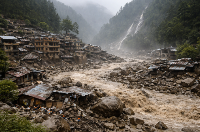
Dharali, August 2025: Consequence, Not Calamity
By August 2025, the accumulated risks converged, and Dharali was buried under a torrent of debris. Intense rainfall, combined with a destabilised moraine at nearly 4,600 metres, triggered a massive debris flow down the Kheer Gad tributary. Moving at nearly 9 metres per second, mud and boulders engulfed the village, burying homes under 12–18 metres of rubble.
Nearly 60% of Dharali’s infrastructure was destroyed. Houses collapsed like matchsticks. Families vanished overnight. This was quickly labelled a “cloudburst.” But scientific assessments pointed to something more uncomfortable: anthropogenic amplification. Human disturbance: road cutting, construction on old debris deposits, and encroachment into stream channels magnified a natural process into a catastrophe.
When warnings written into the landscape are ignored, disaster stops being accidental, and it becomes procedural. Therefore, Dharali was not simply unlucky; it was exposed, layered with risk long before the clouds burst.
When Development Turns Against People
The cost of this ignorance is not just structural, but it is also deeply human. For residents, fear has become routine. Each monsoon is anticipated with anxiety rather than relief. Cracks in the walls are watched closely. Springs are monitored as they weaken or disappear. Evacuation is no longer an exception; it is a possibility people live with.
Farmers are among the worst affected. Terraced fields carved over generations now resemble scarred battlegrounds. These are not random losses; they are predictable outcomes of ignoring slope stability and natural drainage.
Traditional livelihoods- terrace farming, pastoral grazing, and small-scale tourism are steadily squeezed out, replaced by speculative construction that benefits outsiders far more than locals.
“Tourism was supposed to help us. But most big projects benefit outsiders. Locals are left with the risks.”
— Devendra Rana, 34, small homestay owner
Stories from the Hills: Repeated Warnings
- Joshimath: A Town Slowly Giving Way
Joshimath did not collapse overnight. It sank gradually, visibly, unmistakably. Cracks spread across homes, roads subsided, and nearly one-third of the town was declared high-risk. This was not social media panic. It was geomorphology asserting itself. Tunnel construction, road widening, and years of unchecked load on fragile slopes finally caught up; subsequently, what's happening in Joshimath is a warning, not an anomaly.
- Raini Village: Punished for Resistance
Raini is where the Chipko Movement was born, where women once hugged trees to stop deforestation. Decades later, the same village faced repeated flooding and slope instability due to upstream hydropower projects. Residents reported blasting-induced cracks, drying springs, and altered river behaviour. Their protests were dismissed as “anti-development.” The irony is brutal: a village that once protected forests now watches development dismantle the very safeguards it fought for.
- Pithoragarh and Bageshwar: Roads That Refuse to Stay
In eastern Uttarakhand, freshly built roads collapse every monsoon. Hill cutting ignores soil structure and natural drainage. Slopes fail predictably. Villages are cut off for weeks. Ambulances stop. Children miss school. Supplies run thin.
These are not headline disasters, but just chronic neglect. And that makes them easier to normalise.
- Tehri: Displacement Without Closure
The Tehri Dam displaced thousands with promises of rehabilitation and stability. Years later, many families remain economically stranded.
New settlements lack fertile land. Springs dried up. Farming practices that sustained generations became impossible. This was not a sudden disaster. It was slow erosion, quieter than floods, harder to photograph, easier to forget.
5. Chamoli, 2021: When the River Turned Violent
In February 2021, a massive rock–ice avalanche near Ronti Peak sent a surge down the Rishi Ganga River, destroying bridges, roads, and two hydropower projects. Over 200 people died, most of them migrant workers housed in temporary shelters near construction sites.
Climate change was cited. But experts pointed out the obvious: projects were built deep inside a narrow, high-risk valley, with no buffer for extreme events. Early warning systems were absent, and the workers' camp lay directly in the river’s path.
The river behaved as rivers do. We chose to stand where it would hit hardest.
The Numbers Behind the Pattern
- 60 million tourists visited Uttarakhand in 2023, a fivefold increase since 2000, thus adding strain to infrastructure and ecological systems.
- 90% of forest fires in the state are linked to human activity: deforestation, land clearing, and grazing that exacerbate erosion and soil loss.
- The frequency and intensity of extreme rainfall, a trigger for flash floods and slope failures, have increased, while overall rainfall patterns have become erratic, partly due to climate change and land use changes.
- Flash floods and landslides are no longer rare. In just one recent season, authorities recorded more than 50 chronic landslide sites in the state.
Systemic Fault Lines
The Dharali disaster is a symptom, not an exception. Projects like the Char Dham road widening, costing over ₹12,500 crore, have cut through ecologically sensitive slopes despite repeated warnings.
Satellite mapping has linked hundreds of landslides directly to road cuts and embankment work.
The policy question repeats every year: build faster or build smarter? The mountains don’t care about GDP targets. They respond to physics.
After the Disaster: Silence as Policy
Disasters in Uttarakhand follow a familiar script: official visits, compensation announcements, media attention, ultimately followed by mere silence.
Reports remain unpublished or unimplemented. Reconstruction resumes without addressing structural causes. Villages become references, not responsibilities.
This institutional amnesia allows destruction to repeat itself. For locals, abandonment after a disaster is as damaging as the disaster itself.
Rethinking Development in the Himalayas
“After heavy rain, you can hear the mountain shift at night, small stones first, then larger ones. That sound is warning.”
—Narendra Bisht, 32, local driver, Dharali
Uttarakhand does not need to reject development, but it must redefine it. That means:
- Strict land-use zoning and cumulative environmental impact assessments
- No construction in high-risk zones without geotechnical, hydrological, and seismic studies
- Meaningful community consultation, not contractor-driven planning
- Limits on deforestation, tunnelling, and river diversion
- Livelihood models aligned with ecological capacity, including caps on tourism and traffic
In the mountains, progress is often about restraint and sometimes, choosing not to build at all.
Conclusion: Listening to the Land
As someone from Uttarakhand, this crisis is not distant or abstract. It affects people, villages, and landscapes that form the fabric of everyday life here.
Dharali’s destruction and Kedarnath, Chamoli, and Joshimath before is a warning. If development continues without ecological accountability, more communities will pay the price.
The mountains are not failing us. We are failing to listen to them. True progress in Uttarakhand will be measured not by infrastructure alone, but by whether people can continue to live safely and with dignity on the land they call home.
Sources:
- Supreme Court–Appointed Ravi Chopra Committee Report (2014)
- Joshimath Subsidence Reports (2022–23)
- National Disaster Management Authority (NDMA) & Ministry of Earth Sciences
- News reports: TOI, ETV Bharat, News18, NDTV