
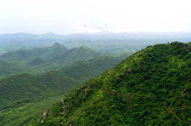
Picture an ancient range that has existed for hundreds of millions of years. A range that dates back before the Himalayas themselves and which is shrinking on paper until it has fewer than a few jagged peaks that fit the definition of “hills.” That is not the setup for a dystopian novel; that is the effect of a legal definition applied just this past year, where any elevation that rises fewer than 100 meters above its surroundings is, by definition, not part of the Aravalli hills. Effectively, overnight, parts of this ancient range are now susceptible to being desecrated by mining and development because, literally, parts of this range “don’t exist” on the map.
What's different? Towards the end of 2025, the Supreme Court adopted a definition of the Aravalli Range based on elevation offered by a committee that considers only elevation of at least 100 meters above the normal relief of the area to be hills. Sets of such hills within an area of 500 meters are then regarded as ranges. The judgment further called on the states to conduct scientific mapping and impose a moratorium on mining till such time that a sustainable plan can be developed. Those who favor the judgment perceive it as objective and can assist in marking out the boundary. Others consider it sterile and deceptive. The hydrological and biodiversity functions of the Aravallis are largely dependent on ridges that are below 100 meters. What is the significance of this number? The Aravalli Range is several hundred kilometers long in the states of Gujarat, Rajasthan, Haryana, and Delhi-NCR regions and functions as a land barrier against desertification and sandstorms while recharging aquifers that support tens of millions of people. This protected area and the requirement that no clearance is needed over the last two decades have been the result of court directives and central government notifications due to the unchecked mining that denuded the hillocks and forests. A huge area of these regions, now assessed as non-‘Aravalli’ under the changed definition in the Eastern Plains of Rajasthan and the southern edges of Haryana, will no longer be protected against mining and construction.
However, the political and administrative fallout has been rapid. Clarifications have been issued by the Union Ministry of Environment, stating that the new notification shall not make illegal large-scale mining the rule and that, according to their initial assessment, only a small fraction of the Aravalli habitat qualification will be eligible for leases, as numbers provided by the Centre, 0.19% of the Aravalli landscape as a whole, but these assertions have neither reassured natural scientists nor stopped them and other environmental activists, as activists tend to, from pointing out holes in the new rules visible on any map and patterns of failure to enforce rules in earlier years.
This is what quickly happens in reality. Take, for example, the Delhi-Gurugram-Faridabad Ridge, where the region comprised a series of contiguous green belts & small hillocks that held back the dust. Quarries & illegal mines have already left their scars; now it will be easier for these & other projects to come up if those hills stand below the 100 m elevation. Another state where this height-measuring criterion could carve away protecting cover for lower slopes & former ridges is Rajasthan.
There are also economic vectors that need to be kept in mind. It so happens that the Aravallis are ore-rich; they have always yielded marble, quartzite, and building stones. It was public-interest litigation in the early 2000s, most notably in the Bhayander checkpost area of Rajasthan, that helped curb a surge in illegal mining after satellite mapping revealed the scale of encroachment. This was because legal approvals had caused poetic dismemberment of the range. Humayun Milletineer, a legal commentator who has written extensively on environmental jurisprudence, argues that an overly narrow definition risks shifting decision-making back into the hands of engineering and mining interests unless rigorous, transparent mapping standards are made mandatory. What is the science and the law advising instead of this hard, unqualified minimum height? Ecologists and hydrogeologists are recommending a science that sees function, not form, whereby landform integrity, groundwater recharge areas, habitat corridors, and natural vegetative cover must be protected regardless of whether a natural landform meets some arbitrary height test. The Supreme Court’s call for scientific landform mapping is a step in the right direction, but according to ecologists, this body of landform maps needs to be transparent, peer-reviewed, and publicly available; otherwise, a 100-meter cutoff will present a paper-thin fig leaf at best.
Thus, there is learning to be done here about how law is done on the landscape. In fact, the Aravalli case reveals how the phenomenon of “disappearance” has repeatedly emerged. It is because governance seeks to translate nature’s complexity into discrete numerical standards and finds itself baffled by how nature falls apart. In fact, “disappearance” is not a geological phenomenon because mountains do not have the capacity to suddenly disappear. Mountains have disappeared from the policy agenda because their significance is reduced to mere numerical standards.
But instead of this happening, as a means of protecting the remaining oldest mountain ranges in India, measures are now required of policymakers: to insist on open and independent mapping; to suspend all leases that are potentially devastating pending the formulation and adoption of multi-criteria maps; the promotion of community guardianship; and the formulation of land use plans that offer compensation for the sake of recharge and biodiversity over extraction. Otherwise, the 100-meter rule may be remembered as the moment when India’s oldest mountains did not erode but were defined out of existence.
Sources:
- https://www.ndtv.com
- DTE Staff, & DTE Staff. (2025, December 5). Aravalli Debate: Why the 100-metre rule has sparked fresh concerns. Down to Earth. https://www.downtoearth.org
- https://www.business-standard.com
- Tanishka Shah. (2025, December 8). How the Supreme Court’s new definition of the Aravalli redraws the landscape of India’s oldest hill range. The Leaflet. https://theleaflet.in