
Transport is the invisible thread that connects people, thoughts, and goods all over the world. From old trading paths that became modern highways, airports, and shipping lanes, the way people move has always been shaped by geography.
Geography, in the simplest sense, describes the natural properties of landforms, climate, waterways, and resources, and how they influence where we settle and how we connect with each other. When it comes to transport, geography not only determines where infrastructure can be built, but also its design, cost, and long-lasting effects on the environment. Understanding the geography of transport helps us appreciate why some areas are activity centers, why some areas remain isolated, and what environmental results come with the expansion of our global transport network.
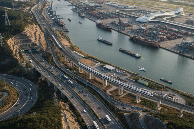
For centuries, rivers, seas, and coasts have played the most important role in transport. The first civilizations along the Nile, Tigris and Euphrates, and Indus rivers flourished because the waterways provided a natural means of transferring people and goods. Boats and vessels can carry heavier loads than animals traveling on the ground. Similarly, coastal areas such as the Mediterranean were lively commercial centers because the sea converted cities into accessible markets. Geography gave these areas a natural advantage, allowing them to become cradles of civilization. Even today, a large proportion of the world's major cities are found on coasts or rivers, with their transport systems rooted in ports shaped by the physical geography of the region.
On the other hand, mountains have historically created obstacles. The huge Himalayas separate South Asia from Central Asia, which prohibits easy movement except through high-altitude passes. Similarly, the rugged Andes mountains in South America have limited transport along the west coast, even with modern tunnels and roads. Geography acts as what some scholars call “distance friction,” where natural areas slow down or complicate simple movement. In response, ambitious infrastructure projects—tunnels through mountains, bridges across valleys, and curved roads clinging to slopes—have been built, but geography always determines the conditions for these projects. It determines whether such projects will be simple, affordable tactics or a long, decades-long struggle against nature.
Climate is another key geographical factor that shapes transport. In the Polar North, permafrost creates challenges for the construction of stable railways or highways, as melting destabilizes the ground foundation. In tropical regions, heavy rainfall can wash out roads or require more durable construction. Meanwhile, deserts such as the Sahara limit the extension of roads or railways, making large investments less economically viable, not only because of sand and heat but also because of the sparse population. In contrast, temperate regions with relatively stable weather provide a more favorable environment for permanent infrastructure. These climate variations suggest that transport infrastructure cannot be seen independently of the geographical environment where it exists.
Apart from physical characteristics, geography also determines the economic and cultural importance of transport routes. For example, the Suez Canal and the Panama Canal are products of geographical necessities, as they cut through narrow landmasses to connect seas that would otherwise require long journeys. Similarly, mountain passes such as the Khyber Pass or river crossings at the Danube achieved tremendous historical significance as chokepoints for trade and movement. Today, international freight lanes in the Strait of Malacca or the Strait of Hormuz are still important global lifelines due to their simple geographical location. Where geography creates obstacles—places where transport must pass—these places become economically and strategically important.
While transport relies on geography, it also reshapes the landscape and environment. A great deal of work on the construction of roads, railways, or ports often involves clearing forests, changing waterways, and flattening areas. Highways cut through ecosystems, fragmenting animal habitats and sometimes changing the migration patterns of wildlife forever. Large airports are often built on what were once wetlands or grasslands, which displaces ecosystems that may not be easily restored. Railways, while efficient, still create corridors through urban and rural landscapes, affecting development patterns around them. Geography is not only an initial condition but also a participant and a partner in transport development.
One of the most visible results of transport geography is urban expansion. Cities often grow around transport networks—railroad intersections, highways, and riverside ports—because they provide access to supplies. By doing this, transport becomes a focus for human activity, causing some areas to become congested while separating others. This has serious environmental implications, such as increased air pollution in urban transport corridors, the urban heat island effect due to huge networks of asphalt and concrete, and reliance on fossil fuels. In contrast, areas far from major transport networks sometimes remain relatively untouched, preserving ecosystems but also limiting opportunities for economic growth.
With these challenges, society is looking for ways to harmonize transport, geography, and sustainability. Projects such as high-speed rail in Europe and Asia aim to reduce dependence on short-haul flights and lower carbon footprints. Cycling networks and public transport investments are designed to prioritize people over cars. Renewable fuels and electrified vehicles still have similar geographical requirements but also work to reduce environmental damage. At the same time, careful spatial planning—understanding the terrain, protecting wetlands, and choosing resilient areas for infrastructure—is important to balance geographical realities with environmental responsibility.
. . .
SOURCES –