
Heritage monuments are not just stone structures or architectural miracles; They are cultural texts that are built into the landscape, and take memory, identity, and emphasis on history. In geography, they act as nodes of cultural expression, referring to scholars as a geo-cultural space-sustainable region where specific heritage (monuments, ruins, religious structures), traditions, stories, and conversations with abstract dimensions such as traditions, stories, and collective memory. Mapping the inheritance monuments in such places not only provides a way to record the appearance, but also to understand how they provide shape and the social and cultural forms of material in the areas where they stand.
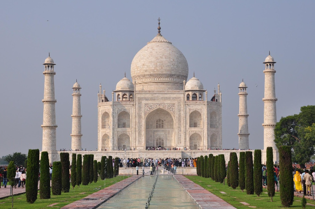
For example, the Taj Mahal in Agra. While globally, the UNESCO is celebrated as a world heritage site and one of the new seven wonders in the world, its relevance extends beyond beauty. Located on the shores of the river Yamuna, its orientation, the choice of the river, and the creation of marble reflect the Mughal geo-cultural imagination of heaven gardens inspired by the Persian effects. To map this monument to the geophysical site, not only its place, but also its work within the cultural heritage of Mughal Heritage, Religion, and Politics of Empire. The crown is not just a symbol of love; Geographically, it explains how the empires manipulated the landscape by manipulating water, stone, and spatial order.
Heritage mapping with geophysical equipment helps to refer to such monuments in the large cultural landscape. Geographical information system (GIS) today allows archaeologists, urban planners, and cultural geographers to record digital memorial sites and put them with theme teams such as historical trade routes, religious routes, or organic areas. A good example is a survey of Ghats, temples, and other sites in Varanasi on foot. Varanasi is often considered the spiritual capital of India, a living city where inheritance is not stable, but is constantly being rebuilt through ritual practice. The GIS-based cultural mapping projects have discovered the density of sacred nodes, pilgrimage patterns, and even religious mantras, to demonstrate how cultural geography merges with living memory. Unlike a museum object sealed in glass, these monuments are associated with everyday life and collective history.
European references reveal parallel processes with geo-cultural significance. Think of the Colosseum in Rome. The location in the center of the Roman forum links it with teams of the royal regime, trade, and cultural performance. Mapping the Colosseum against historical records suggests how its spatial relationship with nearby structures, such as Constantine’s bow or Temple of Venus, makes a palimpsest of history. This particularly presents geo-cultural how modern Rome continues to reverse the Colosseum in everyday identification, Urban branding, and even political debate on cultural heritage management. The structure is not only an archaeological place, but also an active symbol in a landscape saturated with memory.
The Middle East presents another attractive case where monuments create maps of geo-cultural stresses. In Jerusalem, the Dome of the Rock, the Al-Aqsa Mosque, and an incredibly dense symbolic and Western wall coexist in political geography. These places can not only be understood as monuments, but as places where memory, religion, and regionalism overlap. Modern geopolitical mapping, including 3D laser scans and remote measurement, has also allowed scholars and decision makers to preserve, digitally gather, and inherit claims. Here, Jerusalem indicates that the mapping heritage is rarely a neutral function-there is a conversation between historical memory and current geopolitics.
Technological progress in Heritage geography now allows satellite images, drone mapping, and the inheritance landscape during the danger of integrating geophysical cartography. In Syria, the Civil War has damaged monumental places such as the heart of the city, which has caused UNESCO and the heritage to use drone and LIDAR scans to create a digital reconstruction. These digital maps serve double goals: they retain the memory of monuments that can disappear physically, and they enable future reconstructions through 3D modeling. The Palmyra Roman theater, temple, and Colonnades were part of the Silk Road heritage, which symbolized cultural exchange in the area. Their destruction and later mapping give the example that geo-cultural heritage is physically delicate, but can still bear as a coded memory in digital form and human consciousness.
India’s own mapping of postcolonial heritage mapping shows another layer of complexity – interaction between indigenous memory and colonial stories. The Victoria Memorial in Kolkata, built as a monument to the British Empire, has been transformed into a national museum that now defines the colonial memory of India’s independent identity. The great marble architecture after Taj Mahal is located in the architectural landscape of India, but still its great presence in Kolkata, the capital of Colonial Bengal, talks about the royal authority. In order to map the Victoria Memorial Geo-Culturally, we must look at it both as a colonial place for dominance and reorganize it for tourism, the celebration of Bengali culture, and urban identity.
In addition to the iconic examples, the lesser-known monuments also reveal in rural or indigenous scenarios the importance of geo-cultural mapping. In Nagaland, for example, in villages, the Kucha Stone Memorial and Monoliths’ ancestors’ history and war traditions are registered. Such monuments are not wonderful from an architectural point of view, but they are deeply meaningful in social quarrels that maintain identity. Cultural geographers here emphasize the importance of cultural narrative, where local communities contribute to oral history and spatial stories. The survey of such indigenous heritage challenges the aristocratic orientation of traditional monument preservation, making the extent of geo-cultural places include memorials every day.
In short, the heritage in geo-cultural places is present at the intersection of physical form and abstract significance. In such a scenario, map history and memory show dynamic stories – how the empire, religion, colonial powers, and local communities show their world interviews in the physical place, and how it tolerates the inheritance, or sometimes fractures. The function of mapping is both a geographical and cultural exercise, which requires technical precision through GIS, drone, and 3D modeling, with sensitivity to deep layers of memory and shapes their meaning. Whether it is the sacred routes to Varanasi, the stones that dispute Jerusalem, or the delicate ruins of Palmyra, heritage monuments remind us that geography is not just about the area, but about cultural raids on it. To understand such places, you need to read the story on the spot, to dig the memory in the stone, and to identify it to map the monuments; we simultaneously map man’s living experiences.
References
- Legg, S. (2025). “Contesting monuments: Heritage and historical memory in contemporary spaces.” ScienceDirect. This paper discusses the contestation of monuments across different periods, offering a lens on the relationship between heritage sites and shifting forms of memory in space.
- Tang, C. (2025). “Heritage perspectives on cultural memory and spatial distribution.” Nature. This research uses GIS and memory theory to classify and analyze hundreds of Chinese heritage sites, exploring how cultural memory is distributed and aggregated spatially—key to understanding the concept of geo-cultural spaces.
- Sahay, A., Prasad, S., & Bajaj, A. (2024). “Developing a cultural geomorphology of hazards for heritage conservation: Reflections from Majuli Island of India.” Fennia. This article offers insights into the interplay between cultural monuments, natural hazards, and landscape, exemplifying how geomorphological contexts impact heritage conservation.