
Mapping landslides and the development of regional mitigation strategies is a dynamic field that combines science, technology, and social flexibility. The hills represent the danger of the landscape, coastal threats, urbanization, landslides, life, infrastructure, and development. The journey for mapping the dangers of landslides has come from hand-prepared product maps to a sophisticated spatial model generated by satellite images and artificial intelligence based on local knowledge, while meat strategies now mix engineering science, politics, and ground level.
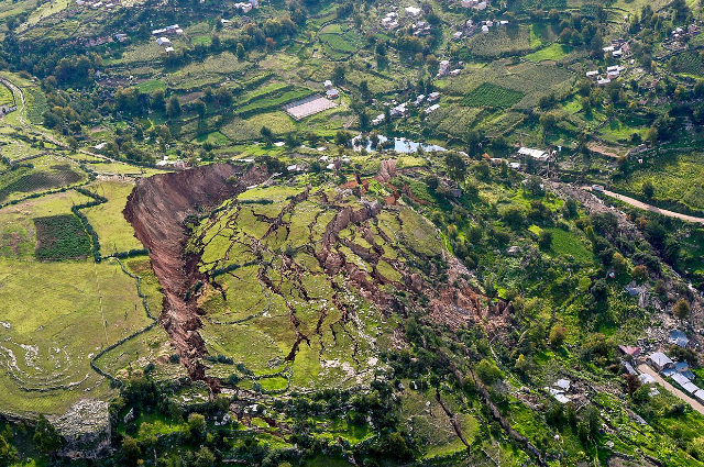
Hazard mapping makes a technical basis for landslide risk management. The process begins with a combination of geological studies, historical records and satellite images, and a combination of remote target data as a combination of remote target data. In India, for example, the geological study of India has mapped most of the Himalayas with the sensitive areas marked on a 1 50,000 scale, and led the development and resource allocation of infrastructure. A classic technology in the landslide zone (LHZ) is the Bureau of Indian Standards (BIS) landslide Hazard Evolution Factor (LHEF) method. This approach divides a region into mapping units, and provides numerical load based on six motivational factors - lithology, structure, slope morphometry, relative relief, land use, and hydrology - and calculates the total estimated threat of each unit. However, cost effects and justice depend on its accuracy, which is much more of a specialist decision, and real factors can be improved by connecting with the real landslide distribution.
Progress in geopolitical technologies has revolutionized dangerous mapping. Satellite remote measurement and GIS are now allowed for the spatial prediction of high-accuracy landslides. In the western Ghats and the robust areas of the eastern Himalayas, researchers use data teams to mix the data layers, using multi-compressing statistical models, logistic regression, and even artificial neural networks – yet, vegetative cover, slope, human intervention, and predictable areas for having a forecast. The real-world use of these methods is seen in Nepal, which provides support for risk reduction projects and the evaluation of a large region in Uttarakhand, where continuous monitoring of drones and radars identified the slope for months, and triggered early warnings and withdrawal.
Global examples highlight the life-saving effects of these innovations. In 2013, Utah’s Bingham Canyon mine was one of the largest historical landslides, consisting of a 65 million cubic meter. Radar monitoring detected the intensification of slope movements, enabling the mining operators to empty personnel and equipment, thus avoiding fatal and serious damage. In Norway’s Åkerneset, satellite-based InSAR (interferometric synthetic aperture radar) traces the gradual expansion of slope cracks, which support preparations for future megatsunami events. In the Nilgiris district of India, the mapping of the National Remote Sensing Center led to a redistribution of indigenous species with deep-rooted species to stabilize the slopes after recurrent rain-inspired landslides.
Still, mapping is only the precursor - there are other strategies where scientific insight comes from practical action. Effective mitigation is multi-faceted, including engineering solutions, implementation of policies, and active participation of local communities. A foundation stone is an active land use scheme. Hazard maps live directly in rules for regulatory rules: NO development zones classified as receptive are called non-development zones, while medium-risk regions limit the construction and require strong engineering controls, such as maintaining walls and strengthening the slope. In Himachal Pradesh, the laws have tightened the rules for land use, even if the enforcement remains complex due to cultural monuments.
Vegetation management and bioengineering approaches are powerful natural solutions. Forests with deep, scattered roots - such as oak, pine, and bamboo - reinforce only mountain soil, but control moisture and control the erosion of the surface, both important factors to prevent landslides. Unlike monoculture wooden plantations, native mixed species provide the best long-term stability, as exhibited in restoration projects in Nilgiris and Darjeeling Himalaya. Engineering intervention is from simple drainage improvement - such as stone fingers, surface runoff ducts, and sub-congestion pipes - to weakened highways in hilly areas and large-scale structures built with railways.
Community awareness is important for successful mitigation. The first warning system is now to detect the forearm for sloping failure in geosensors, rain monitors, and satellite foods. These notifications are sent through local authorities, social media, and sirens networks, allowing rapid withdrawal and preparation. In the Chittagong Hill Tracts in Bangladesh, disaster management integrates the efforts of the local institution with regional authorities using real-time communication channels and risk education programs. There are similar models in the UK, the United States, and Japan, where dangerous maps are publicly available and lead residential construction and emergency exercises.
Integration of science with indigenous knowledge improves molding strategies. Residents, with a chronic risk of dangers, often have a rich practical understanding of slope stability, seasonal weather, and traditional coping mechanisms. When researchers and engineers work with local communities, remote measurement data with field comments, the resulting mitigation strategies become more inclusive and stronger. India’s national program for landslides risk reduction and mitigation emphasizes indigenous methods for local participation, institutional capacity building, and permanent risk management.
When climate change increases extreme rain, it is designed to intensify the dangers of landslides, causing refined mapping and adaptive mitigation, and more importantly. Remote measurement, artificial intelligence, geological study, social action, and progressive policy provide hope. Whether it is stabilizing the Himalayas towns, protecting the motorways of Peru, or educating the Himalayas villages, the future of landslides is one of the integrated, technical, and participatory strategies, which meet scientific mapping in flexible landscapes and safe communities.
References