
Behind Leh and Pangong's beaten tracks lies a land of quiet plateaus, revered monasteries, and sky-piercing passes—the neglected border of India's high-altitude wilderness.
Ladakh has, in recent times, become a foremost destination on the international tourist map, luring both foreign and domestic travellers, mesmerised by its awe-inspiring landscape and rich cultural heritage. Around 300,000 tourists visit Ladakh annually, with the area around Leh city being the epicentre of tourism. Some of the top attractions are the royal Leh Palace, the holy Gurudwara Pathar Sahib, the mystifying Magnetic Hill, and sacred monastic complexes like Hemis Monastery, Thiksey Monastery, Spituk Monastery, and Alchi Monastery. The imposing Maitreya Buddha Statue at Diskit and the panoramic Shanti Stupa at Leh also serve as lasting symbols of Ladakh's spiritual and architectural heritage. Outside of Leh, the destination provides unparalleled adventures for adventurous souls. The heart-pounding Khardung La Pass, one of the highest motorable roads in the world, takes adventurers to the otherworldly Nubra Valley, famous for its dunes and double-humped Bactrian camels. The stunning Pangong Tso Lake, renowned for its shifting colours, and Tso Moriri Lake, a peaceful high-altitude lake situated in the Changthang plateau, are examples of Ladakh's harsh beauty. The remote Lamayuru Monastery, commonly known as the "Moonland" because of its exceptional landscape, and the Zanskar Valley, with its sharp river gorges and ice-covered river hiking (Chadar Trek), contribute to the mystique of the region.
On the other hand, South-Eastern Ladakh is still untouched, mainly because of infrastructural shortcomings and the lack of basic services. However, it has an unspoiled, raw beauty—a virgin land inviting connoisseurs of nature and peace-seekers. This far-flung landscape, though sidelined in mainstream travel circuits, is full of potential for eco-friendly tourism if it gets discovered by those who are willing to go beyond the trodden path.
Tangtse–Horong–Chushul Road
Some highways take you to a destination, and then some highways change the traveller. The Tangtse–Horong–Chushul Road, winding from the cobalt arms of Pangong Tso to the strategic position of Chushul, is one such highway. It is not so much a track as a pilgrimage through quiet, loneliness, and desolate majesty, travelling along the lesser-known veins of Ladakh.
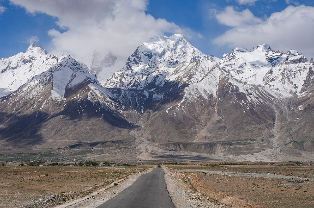
Starting at Tangtse, the base of most Pangong-bound journeys, the road sticks to the edges of the mirror-finish Pangong Tso Lake, whose otherworldly colours change from turquoise to dark indigo with the light. As you step away from the crowds of tourists, the countryside unfolds into Changthang, a windswept plateau where the sky seems perceptibly endless. Travelling through Man-Merak village, tourists are given a glimpse of the high-country herding way of life of the Changpa nomads, whose yak camps and pashmina flocks scatter the barren horizon. The farther inland one goes through Khaltse and Sokmik, isolated villages nested amidst outcroppings of rocks and marshes that are frequently frequented by bar-headed geese and Brahminy ducks in summer.
Changthang- A Refuge in Clouds
The Changthang Wildlife Sanctuary in the Leh district of Ladakh, on the expansive and windy Changthang plateau, is among the largest and most prominent protected areas of the region.
Stretching over an area of around 4,000 square kilometres, as documented by the Ladakh Wildlife Department, this high-altitude haven presents a stark juxtaposition of barren beauty and stunning biodiversity. The reserve is famous for its exceptional topography, scattered with high-altitude lakes like Tso Moriri and Pangong Tso, both of which present a ghostly beauty to the otherwise barren terrain. These alpine wetlands are critical habitats for a wide variety of rare species, most famously the Kiang, or Tibetan Wild Ass, and the Black-necked Crane—a majestic and endangered bird highly valued in Ladakhi society. As one drives along the remote roads that run through this territory, it is possible to catch glimpses of Himalayan marmots sunbathing, wild boars snuffling through dry stream beds, and quick-footed wild hares bounding between boulder outcroppings.
For nature and wildlife enthusiasts, these unanticipated encounters are memories to cherish of the contact they make with the natural world. Farther up the remote crags and dark ridges live the ghostly snow leopard and the Himalayan brown bear, both top predators that move unseen over this harsh environment. Their occasional visits highlight the sanctuary's ecological significance and vulnerability. Not only is it a sanctuary for wildlife, but Changthang home to a variety of rare medicinal plants that thrive in its severe environment.
Within this breadth is Korzok, rated among the world's highest populated villages, where the unyielding ethos of the Changpa nomads and their ancient customs harmonise with the untamed terrain. To travel through Changthang is to cross a world in suspension between earth and heavens—where silence whispers, landscapes inhale, and life, even in its sparse presence, throbs with unbreakable vigour.
A Valley Revealed: The Solitary Ascent to Kaju Kongta La
Kaju Kongta La, sitting at 16,626 feet, is a striking high-mountain pass linking Tangtse and Chushul, which is southwest of the Pangong range. Tucked away from more popular routes, this pass is an important corridor not just for adventure travellers travelling from Pangong Lake to Hanle via Chushul, but also for the strategic manoeuvres of the Indian Army, indicating its geopolitical and tactical importance.
When one embarks upon the climb along this harsh, isolated road, a dreamlike metamorphosis ensues.
There comes a point a visual deception, in which the earth seems to melt away into nothingness, and the twisting road appears to reach the rim of the familiar earth. The landscape grows desolate in its emptiness, resonating with silence and isolation with each bend. Here, the sky feels closer than the earth, and each gust of wind carries with it a monastic stillness, as if nature itself has paused to breathe. Then, just as the desolation seems absolute, the summit of Kaju Kongta La delivers its revelation: a sweeping, ethereal view of the Chushul Valley, cradled in undisturbed silence far below.
The valley emerges slowly, almost reverently, from behind the curtain of stone and cloud, a hidden world bathed in light, cinematic in both scope and sensation. Crossing Kaju Kongta La is not merely a matter of reaching the other side. It is a pilgrimage through isolation and elevation, where the road becomes a metaphor for passage into beauty, into silence, into self. For those who venture along this lost artery of Ladakh, it is an indelible memory inscribed not only in photographs but in the very cadence of the soul. Chushul: Crossroads of History and Geopolitics
Chushul is a small village in the Durbuk tehsil of Ladakh, south of Pangong Lake and west of Spanggur Lake. Though small in size, Chushul is of immense historical, geopolitical, and strategic significance.
It was here, under the lee of the surrounding mountains, that the Battle of Chushul was fought during the Sino-Indian War of 1962, which was one of the most pivotal encounters in the war.
Years before that, in September 1842, Chushul had been the venue for the signing of the Treaty of Chushul, a peace treaty between Gulab Singh, the Dogra ruler of Jammu and Kashmir, and the government of Tibet, terminating the Dogra–Tibetan War practically. The treaty not only created a formal border between Ladakh and Tibet but also confirmed Tibetan sovereignty over its lands.
The location has also held historical importance as a key nexus point on the ancient Silk Route. It was the point of entry into Tibet for General Zorawar Singh, the celebrated Dogra military leader, during his campaign in the early 19th century. Today, Chushul remains at the centre of Indo-China relations.
It is home to one of the five officially recognised Border Personnel Meeting (BPM) points between India and China. These Confidence Building Measure (CBM) sites provide the platform for formal meetings between the top military officials of both countries to avoid misunderstandings and cool down tensions. Though the place itself cannot be visited by civilians, Indian Army installations and even the Chinese road up to the point of the meeting are evidently visible from the road—a silent reminder of Chushul's ongoing significance in contemporary diplomacy and defence.
Rezang La: Where Valour Meets Eternity
Rezang La War Memorial, just opened to the public, is a moving testament to one of the most gallant pages in Indian army history. Set among the barren, gale-swept landscape near Chushul, the memorial commemorates the courageous soldiers of the 13 Kumaon Regiment who lost their lives fighting in the Sino-Indian War of 1962.
In the bone-chilling month of November 1962, an entire company led by Major Shaitan Singh—comprising 120 soldiers—faced an overwhelming enemy force under brutal weather conditions.
Displaying unparalleled courage, discipline, and patriotism, they defended the Rezang La pass till their last breath. Despite impossible odds, they held their ground in a battle that has since become legendary. Major Shaitan Singh was posthumously decorated with the Param Vir Chakra for his bravery, and the whole company's offering is still remembered in the collective heart of a grateful nation. A visit to the memorial is an emotionally moving one.
The silence of the valley, the biting cold, and the stone monument against the blue sky are a sombre reminder of the price of freedom. Tourists are presented with a short documentary of around 12 minutes in duration by the Indian Army, which shows the gruesome battle and the unparalleled courage of the soldiers. The images, voiceovers, and actual testimonies make for a memory that never fades and a truly humbling experience with history. Rezang La War Memorial is not just a place of remembrance—it is a testament to strength, sacrifice, and the unbreakable spirit of the Indian soldier. To be there is to hear the pulse of courage resound through the still mountains.
The Road Less Taken: Uncovering Tsaka La and Beyond
Tsaka La Road is a remote but strategically significant road that runs from Chushul to North Dungti, a distance of around 60 kilometres.
The trek route passes through a high-altitude landscape with sweeping plains, windswept ridges, and a deep feeling of desolation that characterises Ladakh's southeastern frontier. Tsaka La, which is at an altitude of around 15,260 feet, is a tiny village on this path. Despite being small in population and size, it provides breathtaking vistas of the surrounding regions and acts as an important staging point for both civilian and military traffic throughout the area. From Chushul, the road ultimately splits into two distinct routes—one to Nyoma, and the other towards Hanle through Loma.
These roads are frequently taken by travellers going to the inner reaches of the Changthang plateau, such as visitors to Hanle's observatory or to the remote settlements of the high-altitude desert. To drive Tsaka La Road is not merely to travel to an end point because it is an experiential journey across Ladakh's uncharted terrain. With scanty infrastructure, few signs of life, and a silence pervading all, punctuated only by the wind, this road is a true and deeply introspective passage through one of India's most remote corners. Whispers of Gold: Exploring Chhagayung Tso
Golden Duck Lake, also referred to locally as Chhagayung Tso, is a peaceful high-altitude lake located in the remote Ladakh wilderness.
Despite its modest size, the lake has a serene beauty, bordered by imposing mountains and the gentle caress of alpine breezes. What lends magic to this secret treasure is that it is also home to the delicate golden ducks, migratory birds that seek shelter in its peaceful waters. To see these beautiful birds float on the water's surface is a soothing, almost meditative sight. In the mountains' vast expanse of silence, their existence seems almost mythical. All weariness is eradicated the instant one catches sight of the glinting lake, reflected in the soft lapping of water and the peaceful poise of the ducks. Chhagayung Tso is not merely a destination; it is a moment suspended in time and an affirmation that even in the craggiest reaches of the planet, there exists beauty in tranquillity.
Bridges and Beginnings: The Indus at North Dungti
North Dungti is a tiny, peaceful village along the far-off southern section of the road from Tsaka La. Travellers, as they come down towards this border hamlet, are treated to a spectacular view—the very first sighting of the Indus River as it enters India from the Demchok region of Tibet.
There, the Indus meanders gently through the arid terrain, its waters surprisingly clear.
At certain points, the river appears so transparent that one can see fish swimming beneath the surface while seated inside a moving vehicle. This remarkable clarity is best observed while crossing the temporary bridge constructed by the Border Roads Organisation, situated beside the site where a permanent structure is currently under construction. The bridge is not just a crossing over water but a sign of unity in a region characterised by isolation and strategic importance. North Dungti, in a nutshell, provides an instant of peaceful awe where geography intersects with serenity, and where travel itself becomes the destination in Ladakh's harsh and silent borderland.
Crossing Mahe: A Pause along the Roof of Ladakh
Mahe is a small but important town, situated in the southeastern corner of Ladakh, north of Korzok Monastery, and strategically located between Upshi and Nyoma.
Although small, Mahe is geographically and logistically significant because it is situated along major travel routes that link the remote Changthang plateau to the more accessible Indus Valley corridor. One of Mahe's most distinguishing characteristics is the Mahe Bridge, a strategic crossing across the Indus River at an awe-inspiring height of around 4,120 meters. The bridge not only acts as a lifeline for civilian traffic but also fulfils a key role in military and infrastructural connectivity across this high-altitude frontier area. With barren landscapes, clean mountain air, and constant sight of the Indus flowing below, Mahe provides a short but not forgettable break in the journey, where motion converges with tranquillity within the midst of Ladakh's harsh landscape.
Many Faces of Nyoma: Faith, Force, and Frontier
Nyoma is an important town in southern Ladakh, and it is a major administrative and strategic centre in the area. It is a block in the Leh district and is also the location of the Krishi Vigyan Kendra (KVK), an agricultural research and rural development support facility for this high-altitude region.
Geographically, Nyoma is of strategic importance since it is home to a base of the Indian Air Force, and as such, it is a key point for aerial and defence logistics in the Ladakh's southeastern corridor. Its position on the banks of the Indus River, immediately after the river makes its dramatic 90-degree turn at Dungti and immediately before the river begins to constrict into a gorge at Mahe, contributes to its strategic value.
Culturally, Nyoma is also famous for the Nyoma Gompa, a peaceful Buddhist monastery built on a hilltop to the north of the village. Above the river and the valley below, the monastery provides a peaceful location for contemplation and a glimpse at the spiritual heritage of the Changthang region.
Hanle Valley: India's Window to the Stars
Hanle Valley is perhaps the most beautiful and remote area in southeastern Ladakh, lying at an altitude of well over 4,500 meters.
Tucked into the desolate mountains and expansive high-altitude plains, the valley stretches like an untroubled piece of canvas of silence and distance, devoid of commercial tourism and protected from the turmoil of contemporary life. Although it has a population of around 3,000, very few of the inhabitants remain year-round because of the harsh cold and difficult terrain. Hanle's stake in international fame came with the Indian Astronomical Observatory, run by the Indian Institute of Astrophysics.
Situated atop a desolate hill, this is one of the world's highest optical observatories. The arid weather, sparse light pollution, and transparent atmosphere render Hanle one of the finest locations in the world for stargazing. The sky is filled with stars, constellations, and naked-eye visible celestial activity at night—a luxury in a world that has become increasingly urbanised. The experience is not only a pastime here, but a soul-touching one. Hanle has vast cultural importance as well.
The Hanle Monastery, a 17th-century building that belongs to the Drukpa Kagyu school of Tibetan Buddhism, sits serenely on a soft ridge overlooking the valley. With its old murals, prayer halls, and resident monks, the monastery presents visitors with a glimpse into the spiritual life that has flourished in these mountains for centuries. The serene buzz of incantations, the flutter of prayer flags, and the silence around evoke a sense of profound thought and serenity. Hanle is also situated close to sensitive border areas, and access frequently entails Inner Line Permits for Indian citizens and special permissions for foreigners. Being close to the Indo-China border, the area is strategic and under the surveillance of the Indian Army and ITBP.
Over the past few years, Hanle has emerged as a hub for speciality tourism, drawing astrophotographers, seekers, researchers, and adventure-seekers. The government of India is also trying to develop Hanle as a part of India's first Dark Sky Reserve—a specially designated space for keeping the night sky safe from artificial light, encouraging eco-tourism and scientific sensitisation.
Umling La: The Highest Motorable Road on Earth
Umling La, which has an astonishing height of 19,024 feet (5,799 meters), is presently the world's highest motorable road.
Even though many think that Khardung La (17,582 feet) on the Leh–Nubra road is still the highest, Umling La has left it way behind, enjoying global fame in the past few years. Some 80 kilometres from Hanle village, Umling La is a desolate, wind-whipped mountain pass that puts both vehicle and traveller to the test with its sheer altitude, thin oxygen, and rock-strewn terrain. But for the fortunate few who attempt it, the payoff is indescribable: rolling vistas of endless plateaus, ridges blanketed in snow, and an almost palpable feeling of reaching out and touching the heavens. Umling La at 5,799 meters is 435 meters above the Everest Base Camp at 5,364 meters and provides a dreamlike and unparalleled high-altitude road experience.
The journey to Umling La follows the Hanle–Demchok highway, in an area characterised by the sparsity of human settlement, scenic vistas, and strategic value. Historically, the ancient pilgrimage and trade route from Ladakh to Tibet, which was directed towards Mount Kailash and Lake Manasarovar, previously followed alongside this area, along the left bank of the Indus River. Although those ancient routes are nowadays shut by modern borders, Umling La reverberates the spirit of those expeditions, standing now as a wonder of new-age engineering and a testament to human resilience in extreme climes. Eastern Ladakh stretches like an eternal canvas, where the great Indus River writes a glistening ribbon across arid valleys, silent deserts, and ancient mountains.
Meandering with serene power, the Indus inscribes its course through an austere, high-altitude terrain, supporting precious life in an otherwise silent and stony land. From the curve near Dungti to its deep gorge beyond Mahe, the river copies the sky—piercing, fidgety, and forever flowing. Beauty in Eastern Ladakh is one of contrasts: the quiet of wind-scoured plains next to the soft flow of the Indus, monasteries on ridges guarding turquoise streams, and golden light overflowing across ochre hills during the evening. Here, the old trade routes, the military posts, and the nomad tracks all coexist with migratory birds and the occasional yak caravan. Every curve of the river, every quiet passage, murmurs tales of resilience, faith, and discovery. To travel across Eastern Ladakh along the Indus is not just travel, it is meditation in movement, a journey through horizons that humble the spirit and widen the field of thought.