
The Himalayas are undoubtedly the most popular mountain range amongst all Indians; it is practically βlive. These trees are tall, visible, and dramatic. On the contrary, the Aravallis hardly make an impact. They are elderly, low-lying, and often confused with waste hills. On many maps, they appear as fine lines, easily missed.
Nevertheless, the Aravallis indeed are one of the most important geographical features supporting life in North-western India.
The Aravalli hill system on Earth is estimated to be almost two billion years old. While time has lowered its stature, it has not dimmed its significance. What these hills do for India cannot be captured by lines of elevation or tourist brochures. Their actual work occurs behind the scenes, influencing the climate, water, and habitability.
The Desert Barrier No One Notices
One of the Aravallis’ most critical roles is acting as a natural shield against the Thar Desert.
The range slows hot desert winds and influences rainfall patterns across Rajasthan, Haryana, and western Uttar Pradesh. Areas east of the Aravallis historically receive more rainfall and support agriculture more reliably than regions to the west. This difference is not accidental. The hills disrupt wind flow and help retain moisture.
When sections of the Aravallis are mined or flattened, desertification begins to creep eastward. What looks like harmless stone extraction slowly changes entire microclimates. Villages that once had functioning wells begin depending on tankers. The desert advances without warning signs.
Delhi’s Hidden Climate Regulator
Delhi owes more to the Aravallis than it realises.
Delhi Ridge is a surviving remnant of this old mountain range. It serves as a natural temperature controller as well as a dust barrier for the city. Areas adjacent to the ridge are generally somewhat cooler and experience better air circulation than heavily concretised areas.
In northern India, dust storms occur, which are slowed down by the Aravallis so that particulate spread is reduced. As the ridge gets cut, built over, and encroached upon, Delhi becomes more susceptible to heatwaves, dust pollution, and erratic weather.
Cities waste crores on artificial solutions, while they destroy the one system that has worked for millions of years.
An Underground Water System That Keeps Cities Alive
The Aravallis perform the most vital but invisible role.
Rainwater from these hills flows into the ground, which replenishes aquifers within Rajasthan, Haryana, and some parts of Gujarat. Cities like Gurugram, Alwar, Jaipur, and Faridabad show heavy reliance on this groundwater.
A powerful real-life example comes from Alwar district.
Due to the collective work to restore traditional johads and protect the Aravalli catchment the river Arvari is revived along with other dried rivers. Villages restored access to water throughout the year, which was previously dependent on tanker water.
Infrastructure was not built anew. The land was simply left to its own devices.
After being mined or built on, aquifers collapse and take decades to recover, if they ever do.
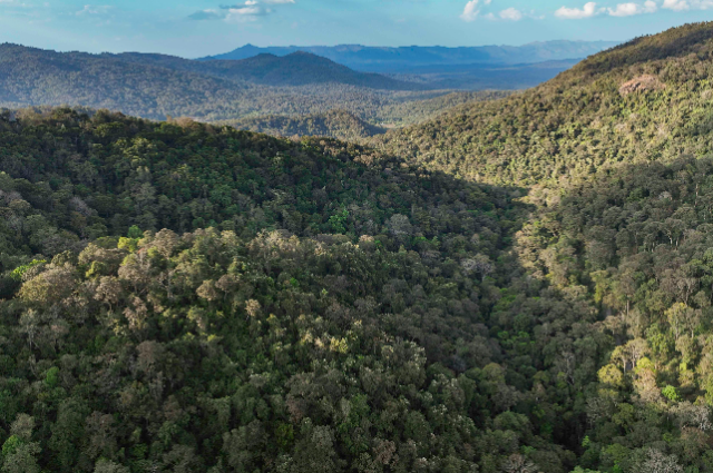
A Living Ecosystem Disguised as Wasteland
The Aravallis are often labelled as wasteland.
This is a perilous confusion.
The dry deciduous forests, medicinal plants, birds, reptiles, leopards, hyenas, jackals and countless other species thrive here. Protected areas, such as the Sariska Tiger Reserve, and initiatives like the Aravalli Biodiversity Park in Gurugram, show how rich this ecosystem is.
When wildlife corridors are disrupted by roads and real estate, animals encroach into human settlements. Rising Human-wildlife conflict is not due to increasing aggression of animals but due to shrinking spaces.
Mining, Urban Growth, and Slow Environmental Collapse
Mining in the Aravallis was banned in court orders, but illegal mining continues at various places in Rajasthan and Haryana. Hills are bombed for stone. Reclassification of forest land. Recharge zones vanish beneath concrete.
The damage is gradual and not drastic. Declining groundwater levels year after year. The summers are getting hotter. Increased flooding happens when rainwater doesn't soak into the ground.
By the time you see the effects, the system is already broken that stopped it.
Why Maps Fail to Tell This Story
Maps display elevation and position. They don’t show function, does it?
They do not prove how a low mountain range can control climate, store water underground, suppress a desert, hold back a desert. The evidence does not demonstrate how the destruction of a hill in one district influences water security in another district.
The significance of the Aravallis is unannounced. They just do.
That's why they are very easy to overlook.
Beyond sinful, more delicate than we think.
The Aravallis were present before human beings. They encountered seismic activity, altering weather patterns, and mass deaths. Yet today, they are being dismantled within a few decades for short-term economic gain.
It took billions of years to evolve, but now it is disappearing faster than we can value it.
What took billions of years to form is being erased faster than we can measure its value.
The Aravallis are not just an old mountain range. They are climate regulators, groundwater managers, biodiversity protectors, and silent stabilisers of life across large parts of India.
They may not dominate maps, but they shape reality.
And once they are gone, no policy, technology, or reconstruction project will be able to replace what they quietly provided all along.
References:
- Ministry of Environment, Forest and Climate Change (MoEFCC), Government of India Official notifications and reports on Aravalli conservation, mining bans, and forest protection.
- Centre for Science and Environment (CSE) Articles and explainers on desertification, groundwater recharge, and the ecological role of the Aravallis.
- Down To Earth Magazine In-depth reporting on illegal mining, water depletion, and environmental damage in the Aravalli range.