
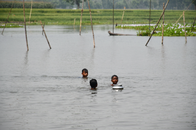
The discrepancies in official data during urban flooding in the areas of Lailapur and Guwahati are often due to official tracking separating logging from riverine rural floods or counting only displaced populations in formal relief camps rather than residents facing severe waterlogging. Assam continued to grapple with the aftermath of devastating floods on Sunday, with the death toll sustaining 82 and across seven districts, nearly 1.78 lakh people are still affected.
There are some areas where flood waters are receding, but thousands were displaced, submerged agricultural land, and the state government has intensified relief, rehabilitation and long-term efforts. According to the Assam State Disaster Management Authority (ASDMA), the number of affected people declined from 1.92 lakhs to 1.78 lakhs, as the flood situation slightly improved. But the 349 villages across Golaghat, Sivasagar, Charaideo, Jorhat, Bajali, Dhemaji and Sonitpur districts are still affected. Charaideo is the worst district, where 75,00,0 people are affected, followed by 58,000 in Sivasagar, and nearly 15,060 hectares of crop area are submerged, and thousands of lives were affected. Assam is one of India’s most flood prone flood-proneund 40 per cent of its arable land is vulnerable. The Brahmaputra River carries massive sediment loads, weakening the embankments over time. The Assam floods in this year 26 made a difference, as it shifted its pattern due to extreme rainfall in the Naga hills and Arunachal Pradesh, which triggered rapid flash floods in the south bank tributaries such as Disang and Dikhow. The rivers swelled and breached embankments before the main channel of the Brahmaputra reached its peak discharge. According to 24th July 2026, reprts say that more than 7.2 lakh people are been affecteund 10 districts, and by that time, the number of deaths rises up to 47. Thact of this particular disaster is unique is that the upper Assam regions like Sivasagar, Charaideo, etc. have never experienced floods on such a scale where flooded. But in the decades, parts of eastern Assam reported one of the worst flood disasters.
The 2026 flash floods have been caused by excessive upstream rainfall in Nagaland and Arunachal Pradesh, in contrast to the typical floods, which happened due to the Brahmaputra overflowing through its banks. The heavy rains in the NAGA hills and Arunachal Pradesh caused saturation of catchment areas, which caused excess surface runoff, and the south bank tributaries, especially the Dikhow, Disang, Dhansiri swelling the rapidly crossed danger mark. Water overflowing from the embankments before the Brahmaputra hits the peak flood discharge point, villages are flooding and causing damage to roads, railway lines, bridges, and cropping land.
The damage caused by the floods – the 10 lakh people affected by the flood, increases the risk of disease, disruption to healthcare services. Waterlogging creates favourable conditions for vector-borne diseases such as dengue, malaria, etc., and contaminated water leads to diarrhoeal illness and leptospirosis. During the recovery phase, overcrowded relief camps, displacement and limited access to clean drinking water heighten the public health risks.
Death toll: The death toll as of July 27, 2026 is 68 deaths,s rising from 47 to 50 to 62 to 66 to 68 over the past week, but till daup to 78se to uup to78. Approx. 40 to 100 people were missing, especially in Nazira and Sivasagar where rescue teams could not reach. The compensation of RS. 4 lakhs announced was per deceased family; even Charaideo, with close to 1.9 lakh people, got affected. There are several reasons due to which Assam experience regular floods. It occupies the rich Brahmaputra valley, which is an extensive alluvial plain, surrounded by the Eastern Himalayas, Patkai hills, Naga hills, Mikir hills, and the Meghalaya plateau. Every year,e rain falls in these ranges, which pours into the Brahmaputra river and its tributaries. The river Brahmaputra is among the world’s rivers with the highest sediment load. The millions of silt which ftons of lows down the mountains accumulate in the valley and gradually increase the elevation, decreasing the ability of carrying to carry factors, mixing with intense monsoon rainfall and riverbank erosion, which causes annual flooding in Assam.
Every year, there is flooding in Assam, but in 2026 it became special due to flash floods in the south bank tributaries. This disaster highlights the importance of upstream or downstream hydrological connection, as the rains in the nearby states quickly lead to massive flooding downstream in Assam. The Indian Meteorological Department (IMD) issued an orange alert for the next three days for forecasting flash rainfall and floods across parts of the North East and East, with fears of fresh spell. According to IMD, thunderstorms and lightning accompanied by heavy rainfall are likely in parts of Assam, Arunachal Pradesh and Nagaland between July 30 and August 1, increasing the risk of floods in vulnerable areas.
A huge amount of rainfall in Arunachal Pradesh, the upper side of Assam and Bhutan crossed the danger mark in the Brahmaputra and other tributaries. This is the main reason due to which floods in Assam affected more than 17lakhs people and places, etc.
References: