
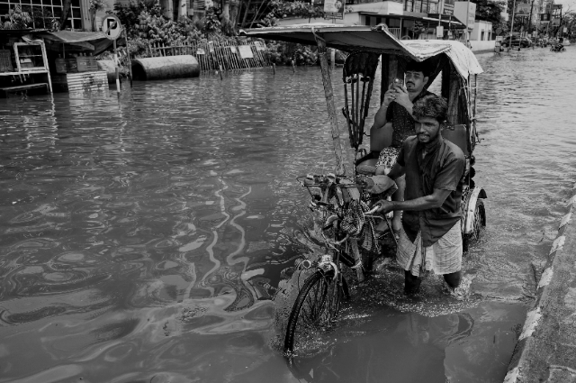
Floods are not an unknown phenomenon in Assam. Every year, when the monsoon sets in, the Brahmaputra River and its tributaries are likely to wreak havoc on the people, their lands, roads, and property in Assam. However, the 2026 floods seem to have thrown up a new scenario. Rather than the floods being caused primarily by the spillover from the Brahmaputra River, much of the destruction caused during the floods was witnessed in Upper Assam following heavy rains in the hills of Nagaland and neighbouring regions that swiftly flooded tributaries like Dikhow and Disand.
However, by the end of July, thousands of households had already been affected in places like Sivasagar, Charaideo, Jorhat, and Golaghat. At one point, there were reports that over 3 lakh people had been affected in the disaster and the total deaths in the region stood at 78. However, as the situation evolved, changes were still made in both numbers. By the beginning of August, the total number of deaths had further increased.
The geography of the disaster is important. Assam’s rivers are closely connected to the surrounding hills of the Northeast. Rainfall does not stop at state boundaries. When heavy rain falls in the hills of Nagaland, water moves downhill through streams and tributaries before entering Assam. If rainfall is exceptionally heavy, these dangerous flooding even when the most extreme rainfall has occurred several kilometres away.
This is what made the 2026 floods particularly challenging. A major river such as the Brahmaputra can be monitored through river gauges and established warning systems. A rapidly rising tributary presents a different problem. Water can reach vulnerable villages quickly, leaving less time for residents to move themselves, their belongings and livestock to safer locations. Roads and bridges can also become unusable, making it harder for emergency teams to reach affected communities.
The experience of a village along the Dikhow River illustrated this danger. In parts of Sivasagar, rapidly rising water caused severe destruction and displaced families. Such incidents demonstrate that a flood does not always arrive as a slow and predictable wall of water. In some situations, it can transform the landscape within hours, cutting off communities that had little opportunity to respond.
That brings up another important question: Why is it that, even though meteorologists are able to predict the occurrence of heavy rain days in advance, there could be such a thing as a devastating flood?
The reason for this is simple – the difference between predicting the weather and predicting the results. Meteorologists can predict with their forecast five days ahead that there might be expected heavy or very heavy rain in a certain area. This is invaluable data, as this information allows governments to mobilise rescue services, gather supplies, identify vulnerable areas and warn people about possible danger. However, the prediction of rain in the area does not tell exactly where the flood would take place.
An alert about an impending rainfall over a vast geographic area may be helpful, but a warning indicating that a specific river would breach a dangerous level after a few hours is much more useful. That is what counts as the major task - how to convert the information from meteorology into practical instructions at the local level.
There has been accumulated a lot of experience has accumulated in Assam with respect to handling floods. Various governmental institutions, disaster response organisations, district administration, local bodies and communities collaborate during floods. Rescue boats are put to use, camps for relief are organised, and food supplies, drinking water, and medical services are provided.
No disaster-response system will ever ensure complete safety from disasters.
For disaster management to be successful, there are many aspects that come into play. Forecasts have to be reliable. Warnings must reach the communities on time. The community must understand these warnings and be prepared to evacuate. The roads must be accessible for the emergency crews. The shelters must be ready, and rescue equipment must be near the affected area.
Thus, the five-day forecast is not equivalent to five days of preparation. It is rather five days of possible preparation. Coordinating the possible into reality is what makes disaster management succeed.
Moreover, it is also evident from the example of the 2026 floods that the recovery phase cannot be assessed merely by monitoring the water level decrease. After the floodwaters subside, the emergency becomes different. People might find their homes damaged and uninhabitable. The roads and bridges might require repair. There may have been crop losses, loss of livestock, and property loss. Water supplies may become contaminated, and the schools and other public institutions must be thoroughly cleaned.
It is thus an important element of the response plan. The Assam government was already providing compensation payments to the impacted families as the situation started shifting from rescue to recovery mode. It was also moving towards the process of digitally surveying and assessing flood damages. This is necessary as rebuilding after the floods will require an understanding of what has been lost and what kind of help is needed.
There is a broader lesson that can be drawn from this disaster regarding extreme weather conditions. It would be naïve to assume that the particular flooding is a direct result of climate change. The flooding in Assam can be caused by several factors, including monsoon rains, river structure, erosion, settlement pattern, and infrastructure. However, the increased prominence of heavy rainfall events makes preparing for such situations harder.
The floods that occurred in Assam in 2026 are thus not just another entry into the list of flood disasters suffered by Assam. It serves as an indicator that modern-day disaster management requires a certain level of quickness on the part of governments. While a weather forecast provides about five days of warning, a swiftly rising river tributary could make the difference in hours.
What should be the true test of preparedness would not only include knowing that there will be heavy rains coming, but whether that information was relayed to the correct people who could act on it.
The true test for Assam is to ensure that the link between a forecast and disaster management becomes as strong as possible. While Assam cannot stop any extreme rainfall and cannot control its rivers, it can improve its systems that are placed between forecast and catastrophe.
References:
- https://timesofindia.indiatimes.com
- https://www.asdma.gov.in/cumulative_reports.html
- https://mausam.imd.gov.in
- https://asdma.assam.gov.in/resource/assam-flood-report
- https://m.economictimes.com