
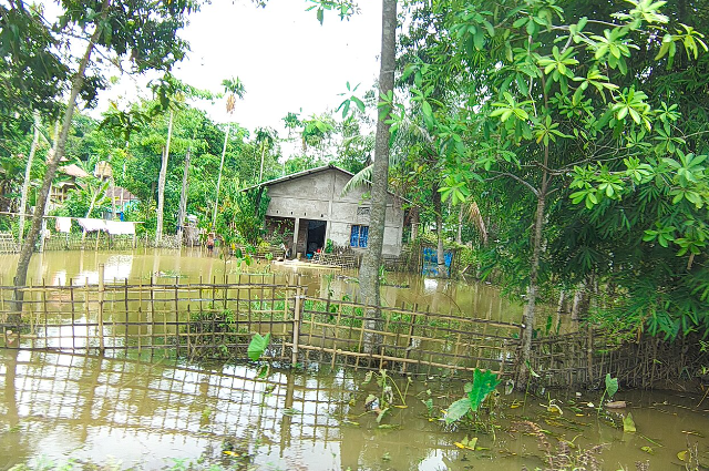
Assam is no stranger to flooding. Every year, torrential downpours cause rivers to overflow their banks, submerging vast areas and displacing thousands of people across the state. But this year’s monsoon seems to have been particularly damaging.
This year’s situation seems to have been exceptional due to a combination of factors, the most crucial of which is the location of the deluge. Unlike the usual Brahmaputra riverine floods, this year, the upper Assam region witnessed an unprecedented level of devastation due to overflowing tributaries and an exceptionally high volume of water run-off.
People in districts such as Sivasagar, Charaideo and Jorhat - some of the hardest hit regions this year spoke of waters and flood levels far beyond what they have seen in their lifetimes.
According to media reports, as of July 28, the death toll due to the Assam floods had already crossed 75, with over 3.3 lakh people affected in seven districts. The number of affected people peaked at 3,00,031 as of July 30, with the number of deaths climbing to 78. As of August 8, the death toll due to the Assam floods climbed to 98. While the number of people affected decreased due to receding waters, the number of districts affected still stood at 13.
One of the main reasons why this year’s Assam floods have been an unprecedented event was due to the confluence of a number of factors, one of which was the overflow of several tributaries as well as the Brahmaputra itself.
While the Brahmaputra river is infamous for its overflowing banks, this year, the flood waters in the upper Assam region came largely from the Dikhow, Disang and other tributaries. For instance, the Assam Tribune reported that on July 22, the Dikhow river in Sivasagar was in a “severe flood condition”. The Disang river in Nanglamoraghat and the Dhansiri river in Numaligarh were also flowing at “severe to extremely deep flood levels”. Thus, the flood waters in several of Assam’s tributaries this year were exceptionally high.
The flood waters that caused massive destruction were driven by several factors, one being the abnormally high rainfall witnessed in upper Assam’s hilly regions.
The reason behind this can be explained by looking at the conditions in Nagaland’s hilly areas. In the Mon district of Nagaland, torrential rains led to severe flooding this year. “Heavy rains lashed the state’s hill districts from July 18 to 20,” The Indian Express reported, citing the India Meteorological Department (IMD). Wokha received 239 mm of rain between July 18 and 20. Other hard-hit districts were Mokokchung (167mm), Mangkolemba (211mm) and Longleng (152.2 mm). On July 18, Sonari in Charaideo district of Assam received nearly 190 mm of rainfall on July 18 alone.
One of the reasons behind the destructive flood waters in Assam this year was due to the high speed at which the water rushed downwards.
Rainfall leads to surface run-off, which can accumulate as water in streams and rivers. If the ground through which the water is flowing is already saturated, then the amount of water that can be absorbed decreases substantially. As a result, more surface run-off accumulates as water in smaller water bodies. The large amount of surface run-off, in turn, adds to the volume of water in rivers, especially if the streams and rivers are downstream of the region which witnessed heavy rainfall.
While Assam is particularly prone to flooding, it is a misconception that all of its districts are similarly cursed with yearly deluges. Assam’s geographical composition is such that the Brahmaputra and its tributaries form a riverine system which witnesses flooding almost every year. However, the amount of water run-off, river levels, local drainage, and the nature of the landscape can vary drastically across different districts, determining how badly a region is hit by the monsoon. Upper Assam, according to The Indian Express, was particularly badly hit by this year’s Assam floods due to the amount of destruction caused, with the flood waters peaking at levels higher than people had seen in their lifetimes. According to the report, people in districts such as Sivasagar and Jorhat said that the monsoon waters and flood levels this year were far higher than what they had ever witnessed. “Even after the waters began to recede, many areas were inaccessible due to the silt deposited by the flood waters,” the report added.
One of the initial reasons speculated for the Assam floods this year was a cloudburst which occurred in the Mon district of Nagaland. The Assam government initially blamed the cloudburst for the Assam floods this year, which destroyed countless homes and standing crops. However, the cloudburst theory was later debunked by a scientist from the Meteorological Centre in Kohima. According to The Indian Express, the IMD defines a cloudburst as a rainfall of over 100 mm in one hour. “What happened in Mon was a rainfall of 137 mm in 8 to 9 hours,” the scientist said, adding that while it was an exceptionally high amount of rainfall, it didn’t qualify as a cloudburst.
The reason why the Assam floods this year were so devastating can be attributed to both high rainfall as well as the speed at which it occurred, with the run-off adding to the already overflowing Brahmaputra and its tributaries, causing extensive damage.
According to the Indian Express, researchers and environmentalists have said that the changes to the drainage systems and the destruction of the region’s natural forests and wetlands could have contributed to the Assam floods this year. “Loss of natural infiltration capacity due to large-scale deforestation, degradation of natural wetlands and modifications to riverine and drainage systems in the tributaries could have triggered such a disaster,” the report cited experts as saying.
The modification of the local drainage systems, however, cannot be cited as the sole reason for this year’s Assam floods. Torrential rainfall, especially in the upper Assam region, was the proximate cause of this year’s Assam floods. The changes to the natural landscape of the region can only be said to have triggered the disaster, not caused it.
The distinction is important because it highlights the fact that while the Assam floods this year were a natural disaster, the destruction of Assam’s natural forests and wetlands meant that the Assam floods this year were exceptionally damaging. A natural hazard only becomes a disaster when it interacts with human life, and the impact of such a disaster is often increased due to human intervention.
Another issue is the possible impact of mining activity in the region. Various political parties and environmental activists have accused several mining companies of destroying the hill tops and modifying the drainage systems in the Assam-Nagaland border rhilltopsntributing to this year’s Assam floods. The Assam government, however, has been careful not to politicise the Assam floods this year. As The Indian Express report noted, authorities in Assam have said that while they will look into the impact of mining on the Assam floods this year, it is best to leave the “political tussle” for later. “Issues of relief and rehabilitation have to take priority over everything else,” the Assam government said.
Changes to the drainage systems may have played a role in the Assam floods this year, but it is best to leave that to experts to determine.
The Assam floods this year are an environmental issue which deserves to be addressed with scientific precision and without partisan interference. But another question which needs to be asked is if the modifications to the landscape and natural drainage systems in Assam have made it more susceptible to Assam floods. If the hills and wetlands are no longer able to store excess rainwater, then even a small amount of rainfall can lead to disastrous flooding.
Another possible reason for Assam’s floods this year is an external factor which cannot be controlled: climate change.
Warmer temperatures lead to more moisture being held by the air, and as a result, there is a higher chance of extreme downpours occurring. The Indian Express report on Assam’s recent deluge noted that one reason for the Assam floods this year was the excessive rainfall, which could very well be a result of climate change. The modification of Assam’s natural landscape, however, made the Assam floods this year far more damaging than they would have otherwise been. According to climate scientists, extreme rainfall events in the present day are increasingly common as a result of climate change. And for a region such as Assam, which is home to large rivers, hills and extremely high volumes of monsoon rainfall, such a situation can only lead to disastrous flooding.
By late July this year, flood waters had begun receding from several regions in upper Assam. The Assam floods this year, though unprecedented, were far from over. The Assam Tribune reported that even as the waters began to recede, houses, roads, schools, and crops were all submerged under water. The residents of the region would now have to start rebuilding their lives, as the flood waters deposited sediments in the region.
The government has provided various relief measures such as ex gratia payments to the families of those lost in the Assam floods this year. The government also announced financial aid to people and families who were worst hit by the disaster in August this year, as a result of which many people and families in several districts of Assam have been directly affected by the Assam floods. While the waters from the Assam region this year may soon recede, the long term effects of the disaster will continue to have an effect on the long-term.
For centuries, Assam’s floods have been a recurring disaster which has claimed hundreds of lives and submerged thousands of homes every year. Over time, several mechanisms have been developed to tackle Assam’s recurrent deluge, such as embankments along the river banks, improved drainage systems and more. While these initiatives have helped, Assam’s floods this year show just how inadequate they are when it comes to truly preventing large-scale destruction.
Assam’s flood problem cannot be tackled by looking at the rivers in isolation; the entire ecosystem has to be taken into account. Wetlands, forests, hills, river banks and drainage systems all play a crucial role in helping manage Assam’s monsoon, and it is when these elements are disrupted that Assam’s floods become truly damaging. The Assam floods this year, for instance, were not just due to high river levels; they were also the result of modifications to the region’s drainage systems which led to higher-than-usual volumes of water run-off. Thus, to truly manage Assam’s floods, it is best to take a holistic approach which takes into account all the elements which contribute to Assam’s deluges.
References:
- https://timesofindia.indiatimes.com
- https://indianexpress.com
- https://m.economictimes.com
- https://indianexpress.com
- https://www.indiatodayne.in
- https://theprint.in