
Image by J Lloa from Pixabay
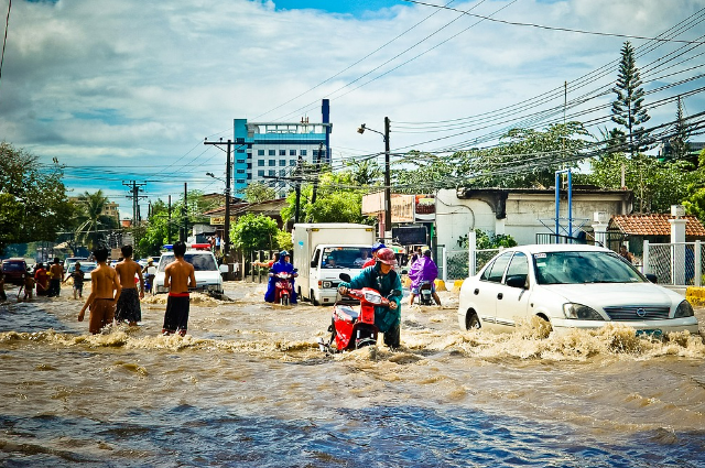
There had always been a hypothesis of two Indias in the intelligentsia. But rarely does it happens that the Disaster merges a thin line between them. The images of an inundated capital city of India, with citizens stranded homeless; technicians out for rooftop rides, and highways transformed into sewer canals might be a new experience for NCR but is an annual phenomenon for megacities like Mumbai, Chennai, or Bengaluru. What do these cities have in common? And more importantly what solution can save the day? Let's get into the core of the problem first.
THE CAUSES
May it be Delhi or Mumbai or even Bengaluru, the cities have a unique saucer-shaped Topography with Centripetal or Indand drainage patterns. As the natural streams are concretized, the water from monsoon falling in the catchment areas gets collected in downtrodden areas of settlement having no way out.
Mumbai is on a narrow peninsula on the southwest of Salsette Island built on what was once an archipelago of seven islands: Isle of Bombay, Parel, Mazagaon, Mahim, Colaba, Worli, and Little Colaba.
From 1782 onwards, the city was reshaped into a single amalgamated mass merging all the seven islands of Bombay.
Many areas lie just above the sea level having an average height of 8 to 10 m above sea level. As the city gets hit by heavy monsoon showers for about 4 months each year, about 70 percent of settlements get inundated including high-profile areas.
The Nation Capital Region is a prime example of unplanned, overburdened settlement in the Yamuna flood plains and the Delhi Ridge. The denudated Aravalli has a natural slope towards the plains. The city gets showers from the Arabian Sea branch of the southwestern monsoon while Aravalli's acts as a parallel funnel. The low-pressure belt attracts showers from the Bay of Bengal branch as well.
Delhi still works on the drainage masterplan of 1976. IIT Bombay suggested Restructuring in 2018. Which is yet to be implemented. The water from upstream's gets deposited in the Yamuna River, especially during the heavy runoffs which terraform Yamuna from the narrow ribbon of polluted sewer into its mighty form. The upstream areas have poor capacity for runoff storage and management. 2023 saw the monsoon currents intensified by western disturbances causing the most severe flooding of the city since 1978. (In 1978 the river touched the mark of 207.49 m, currently which is at 205.33 m in 2023).
The flooding of Bengaluru in 2022 came as a major eye-opener for the tech city dreamland of India which was once a "city of lakes". But multiple studies had earlier highlighted the vulnerability of the city to localized urban flooding.
The city lost 88 percent of its natural vegetation cover and about 78 percent of its natural streams and water bodies in the last 50 years. Government data claims that the city earlier had a total of 260 lakes in the 1940s which has dropped to 65.
Little attention was paid to regulating and conserving the floodplains. The natural lakes encroached to stylize the mass urban settlements which led to large-scale stagnation of water in India's 5th most populous urban agglomeration.
Karnataka administration recently had delayed enlightenment to approach the World Bank to seek funding to prepare and execute a permanent solution to end flooding in Bengaluru during monsoon.
Chennai has a sorry reputation for being an annual Atlantis for years now. Chennai's terrain is close to the sea level. The city has dense urbanization with too much concrete and tar and no natural buffers like lakes or watersheds or even open sources. As the city receives bi-seasonal showers from South West Monsoon as well as North East Monsoon. The stormwater drains are ill-designed according to rainfall data although officials may claim so. As Rainwater can't move anywhere, it stagnates in the terrain.
THE SOLUTIONS
The most prominent and surprising contradiction that emerged amidst the Disaster of the year is, the settlement of Noida survived the heavy showers while the Equitable counterpart of Gurugram found itself submerged.
Both the bustling satellite settlement has a population of about 30 lakhs. The crucial contrast lies in meticulous planning and effective water management. Noida has an extensive network of 87 kilometers of large storm drains flushing all the water either in Hindon or in the Yamuna River, whereas Gurugram solely relies upon drains measuring less than 40 kilometers. Noida has many strict criteria for land acquisition which encompasses the road infrastructure, well-established sewer systems, and preparedness resulting in minimal instances of waterlogging within the city. While waterlogging may occur, it gets swiftly cleared because of having superior solid waste management and disposal than Gurugram.
Sometimes modern problems require age-old but sustainable solutions. During the 2004 Indian Ocean Tsunami, the entire western coast was submerged except few temple towns near the Malabar coast. The post-Disaster scientific review showed that these areas had a superior wetland, heterogeneous masses of vegetation, and mangrove cover which was considered sacred by villagers. It acted as an efficient absorber of the floodwater. The pneumatophores of mangroves retain sediments and prevent erosion, while the roots, trunks, and canopy reduce the force of oncoming waves and storm surges and thus reduce flooding. Similar might had been the situation in Mumbai if the savior vegetation could have survived construction lobbying for sea-facing luxury apartments.
Urban areas have many surfaces that prevent water from draining into the soil. Concrete drainage channels and sewers also have their own limitations.
In North America, citizen scientists found an efficient solution in road bank spills, which act as small artificial wetlands connected with perforated pipes from below, which efficiently sponges swollen drainage. Japan has its indigenous Miyawaki forest technique which includes planting native plant breeds in the URBAN FOREST area that grows maintenance-free, More Faster & More Denser. Miyawaki forests grow in 2 to 3 yrs & are self-sustaining. In addition to pollution control, they are reliable water management and groundwater recharging agents.
As disasters and extreme weather events are here to stay with unforeseen scale and severity, we just have two options. Either we migrate towards a more scientific, Sustainable, and disaster Resilient urban landscape or we keep an extra lifeboat in our backyard.