
Image by dita niesnerova from Pixabay
Abstract
Groundnut and other oilseed crops play a significant role in the agricultural economy of Telangana, particularly in semi-arid agro-ecological regions. The present study examines the spatio-temporal changes in groundnut and total oilseed cultivation areas across the districts of Telangana using comparative statistical analysis for two periods: 2016–18 and 2022–24. District-wise mean cultivated area data were analyzed to understand variations in cropping patterns and their relationship with Agro-Ecological Zones (AEZs). Results indicate a 35.8% decline in groundnut area and an 11.47% decline in total oilseed area between 2016–18 and 2022–24. Major decreases were observed in traditional groundnut-growing districts such as Wanaparthy, Jogulamba, Mahabubnagar, and Mahabubabad, whereas moderate increases were observed in districts such as Nalgonda, Rangareddy, and Vikarabad. The study also highlights significant spatial variability among districts due to differences in rainfall, soil characteristics, irrigation expansion, and crop diversification. AEZ-wise interpretation indicates that southern Telangana continues to remain an important oilseed region under rainfed conditions, while central Telangana shows declining oilseed cultivation due to expansion of irrigated crops such as paddy. The study emphasizes the importance of region-specific agricultural planning and sustainable oilseed promotion strategies in Telangana.
Methodology
The study is based on secondary data collected from district-wise agricultural statistics related to groundnut and total oilseed cultivation areas in Telangana for the periods 2016–18 and 2022–24. Mean cultivated area values for each district were computed to compare temporal changes in cropping patterns. Descriptive statistical techniques such as total area, mean, percentage change, and standard deviation were employed to evaluate spatial and temporal variability in crop distribution. Comparative statistical analysis was carried out to identify districts showing increase or decline in cultivation area. Graphical representations and district-level comparisons were used to visualize changes in crop distribution patterns. The results were further interpreted with reference to the Agro-Ecological Zones (AEZs) of Telangana, including the Northern, Central, and Southern Telangana Zones, to understand the influence of soil type, rainfall, irrigation availability, and cropping systems on oilseed cultivation trends. The study adopts a spatio-temporal analytical approach to assess regional agricultural transformation and crop diversification patterns in Telangana.
Groundnut (Arachis hypogaea L.) is one of the important oilseed crops cultivated in semi-arid tropical regions of India and plays a crucial role in the agricultural economy of Telangana. The crop is particularly suited to the red sandy loam and light soils predominant in many parts of the state, and it contributes significantly to edible oil production, livestock feed, and farm income. Telangana is divided into different Agro-Ecological Zones (AEZs) characterized by variations in soil type, rainfall, and cropping systems, which strongly influence the spatial distribution and extent of groundnut cultivation.
In Telangana, groundnut is predominantly grown during the rabi season under irrigated conditions, although limited cultivation also occurs in the kharif season depending on rainfall and soil moisture availability. The crop is mainly concentrated in the southern and southwestern districts where suitable soils, irrigation facilities, and established cropping systems support its cultivation. Over time, the area under groundnut cultivation may change due to several factors such as irrigation expansion, crop diversification, government policies, market price fluctuations, and climate variability.
Literature Review
Previous studies on oilseed cultivation in India have highlighted the importance of agro-climatic conditions, irrigation availability, and market dynamics in influencing cropping patterns and spatial distribution of oilseed crops. Researchers such as M. S. Swaminathan emphasized the role of sustainable agricultural planning and region-specific crop management in dryland farming systems. Studies conducted by the Indian Council of Agricultural Research (ICAR) and Directorate of Economics and Statistics have shown that groundnut cultivation in semi-arid regions is highly sensitive to rainfall variability, crop diversification, and irrigation expansion. Several regional studies on Telangana agriculture indicate a gradual shift from traditional rainfed oilseed crops toward irrigated commercial crops such as paddy and cotton due to improved irrigation infrastructure and market incentives. Spatial agricultural analyses further reveal that southern Telangana districts continue to maintain significant oilseed cultivation because of favorable red sandy loam soils and semi-arid climatic conditions. These studies provide a strong foundation for understanding the recent spatio-temporal changes in groundnut and oilseed cultivation patterns in Telangana.
A comparative analysis of the groundnut area over different time periods is essential to understand spatial and temporal changes in cultivation patterns. Such analysis provides insights into regional shifts in crop preference and helps identify districts or agro-ecological zones where groundnut cultivation is expanding or declining.
The present analysis compares the district-wise mean groundnut area of Telangana during the 2016–18 and 2022–24 periods using statistical measures and graphical representation. The objective is to examine changes in groundnut cultivation across districts and interpret these trends in relation to the agro-ecological conditions of Telangana.
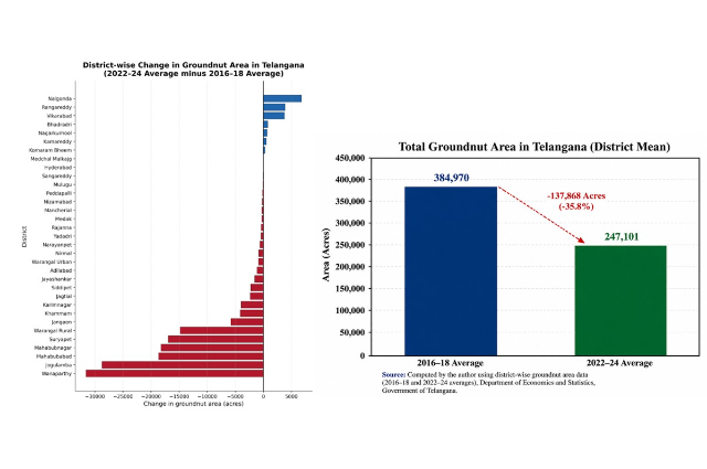
Figure 1: District change in groundnut area 2016-18 and 2022-24b) total groundnut area in Telangana district mean
Statistical Analysis
The statistical comparison was carried out using the district-wise total groundnut area averages for the two periods.
1. Overall State-Level Comparison
Total groundnut area (district mean totals):
Period Total Area (acres)
2016–18 384,970 acres
2022–24 247,101 acres
Change:
Decrease of 137,868 acres (≈ 35.8% decline).
Interpretation:
- The overall cultivated area under groundnut in Telangana declined significantly during 2022–24 compared to 2016–18.
- This reduction suggests crop substitution, irrigation changes, or diversification toward other crops such as cotton, maize, and paddy.
(See Graph 1 above: Total Groundnut Area Comparison)
2. District-wise Change in Groundnut Area
District-level variation shows big spatial differences.
Major Decline Districts
| District | Decline (acres approx.) |
| Wanaparthy | −28,603 |
| Jogulamba | −28,766 |
| Mahabubabad | −18,660 |
| Mahabubnagar | −18,244 |
| Warangal Rural | −14,817 |
| Suryapet | −16,957 |
These districts historically represent major groundnut belts, especially in southern Telangana.
Districts Showing Increase
| District | Increase (acres approx.) |
| Nalgonda | +6,773 |
| Rangareddy | +3,873 |
| Vikarabad | +3,751 |
| Bhadradri | +773 |
| Kamareddy | +516 |
These increases suggest localized expansion or shift in cropping patterns.
3. Spatial Pattern: Key observations:
- Southern Telangana districts historically dominate groundnut area.
- Nagarkurnool remains the largest groundnut-growing district in both periods.
- Many traditional groundnut districts show a sharp decline.
- Expansion is localized rather than widespread.
Conclusion with AEZ reference: The comparative statistical analysis reveals a substantial decline in the total groundnut cultivated area in Telangana between 2016–18 and 2022–24 averages. While the state recorded about 3.85 lakh acres during 2016–18, the area reduced to approximately 2.47 lakh acres during 2022–24, indicating a decline of nearly 36 percent. District-wise analysis shows that the reduction is particularly prominent in the southern dry agro-ecological zones, especially in districts such as Wanaparthy, Jogulamba, Mahabubnagar, and Mahabubabad, which historically formed the core groundnut growing belt. However, a moderate increase in districts like Nalgonda, Vikarabad, Rangareddy, and Bhadradri indicates localized shifts in cropping patterns within certain agro-ecological environments.
In terms of Telangana AEZs, groundnut cultivation remains concentrated in AEZ regions characterized by red sandy loam soils and semi-arid climate, particularly in the southern and south-western parts of the state. The observed decline in area suggests increasing crop diversification and changing irrigation patterns in these zones. Therefore, future groundnut production in Telangana is likely to depend on the sustainability of cultivation in these agro-ecological zones and the adaptation of farmers to changing climatic and economic conditions.
SPATIO-TEMPORAL TOTAL OIL SEEDS AREA IN TELANGANA
Oilseed crops constitute an important component of the agricultural economy of Telangana, contributing significantly to edible oil production, crop diversification, and farmer income. Major oilseed crops grown in the state include groundnut, sesame, sunflower, castor, and other minor oilseeds, which are cultivated under both rainfed and irrigated conditions. The spatial distribution and extent of oilseed cultivation are influenced by agro-ecological conditions such as rainfall, soil type, irrigation availability, and cropping patterns. Telangana is characterized by diverse Agro-Ecological Zones (AEZs), including the Northern Telangana Zone, Central Telangana Zone, and Southern Telangana Zone, each with distinct climatic and soil characteristics that affect crop distribution and productivity.
The analysis of temporal changes in oilseed area provides insights into shifts in cropping patterns, technological adoption, and resource utilization. Understanding these trends is particularly important for planning sustainable agricultural development, ensuring edible oil security, and designing region-specific interventions. In recent years, changes in irrigation expansion, government support programs, market prices, and climate variability have influenced farmers’ crop choices, including the cultivation of oilseeds.
The present statistical analysis compares the average total oilseed area across districts of Telangana for two periods: 2016–2018 and 2022–2024. District-wise mean area values were used to evaluate the magnitude and direction of change in oilseed cultivation. Descriptive statistical measures such as total area, mean, and variability were computed to understand distribution patterns across districts. Graphical representations were prepared to interpret the differences between the two time periods visually. The analysis helps identify districts with increasing or declining oilseed area and relates these trends to the agro-ecological characteristics of Telangana. Such evaluation is useful for research, policy formulation, and improving oilseed production strategies in different AEZs of the state. The dataset used for this analysis is drawn from district-wise oilseed area statistics.
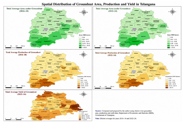
Maps: 1: a) Total average groundnut area (2016-18) b) Total average groundnut area (2022-24) c) Total groundnut production (2016-18) d) Total groundnut production (2022-24) e) Total groundnut yield
Statistical Analysis of Oilseed Area
1. Descriptive Statistics
| Statistic | 2016–18 Average | 2022–24 Average |
| Total oilseed area (acres) | 1,044,802.33 | 924,950.32 |
| Mean district area (acres) | 31,660.68 | 28,028.80 |
| Standard deviation | 38,271.14 | 37,430.19 |
| Percentage change | – | −11.47% |
Interpretation
- The total oilseed area declined by about 11.47% between the two periods.
- The average district area decreased from about 31,661 acres to 28,029 acres, indicating a moderate contraction in oilseed cultivation.
- High standard deviation values in both periods indicate large spatial variability among districts, suggesting concentration of oilseed cultivation in certain districts.
Districts such as Nagarkurnool, Nirmal, Nizamabad, Kamareddy, Wanaparthy, and Sangareddy show relatively large areas under oilseeds, while urbanized districts such as Hyderabad and Medchal-Malkajgiri show negligible cultivation.
Graphical Analysis
Graph 1: Total Oilseed Area Comparison
Total Oilseed Area (Acres)
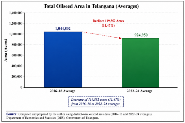
Figure: 6.20 Decline in the total oilseed area during 2022–24 compared with the earlier period.
Graph 2: Average District Oilseed Area
Average District Area (Acres)
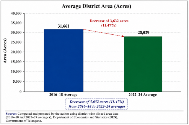
Figure: 6.21 Either crop diversification toward other crops (such as paddy and cotton)
Observation:
The average cultivated area per district has decreased, indicating either crop diversification toward other crops (such as paddy and cotton) or changes in irrigation and market incentives.
AEZ-wise Interpretation (Telangana)
Oilseed cultivation trends reflect the agro-ecological characteristics of the state:
- Northern Telangana AEZ (Adilabad, Nirmal, Komaram Bheem)
Predominantly rainfed black soils support oilseed crops like soybean, sesame, and sunflower. Some districts show continued importance of oilseeds but with moderate fluctuations.
- Central Telangana AEZ (Karimnagar, Jagtial, Siddipet, Kamareddy)
Expansion of irrigation and paddy cultivation has reduced oilseed area in several districts.
- Southern Telangana AEZ (Nagarkurnool, Wanaparthy, Mahabubnagar)
These districts still maintain large oilseed areas, especially under rainfed conditions.
Conclusion: The comparative analysis of district-wise averages indicates that oilseed cultivation area in Telangana declined by about 11.47% between 2016–18 and 2022–24. Despite this reduction, certain districts in the Southern and Northern Telangana AEZs continue to maintain significant oilseed acreage, reflecting their suitability for rainfed oilseed cultivation. Conversely, districts in the Central Telangana AEZ show decreasing trends due to expansion of irrigated crops such as paddy. The results highlight the need for AEZ-specific oilseed promotion strategies, including improved varieties, rainfed crop management, and price incentives, to sustain oilseed production in Telangana.
References
- Indian Council of Agricultural Research (ICAR). Handbook of Agriculture. New Delhi: ICAR Publications.
- Directorate of Economics and Statistics, Government of Telangana. Season and Crop Reports (2016–2024). Hyderabad.
- M. S. Swaminathan (2006). Sustainable Agriculture and Food Security. Chennai: MSSRF Publications.
- Government of Telangana. Statistical Abstract of Telangana. Hyderabad: Directorate of Economics and Statistics.
- Reddy, A. A., and Reddy, G. P. (2019). “Cropping Pattern Changes and Agricultural Diversification in Telangana.” Indian Journal of Agricultural Economics, 74(2), 145–158.
- Food and Agriculture Organization (FAO). Oilseed Production and Sustainable Agriculture Reports. Rome.
- Bhattacharya, P. (2018). Agricultural Geography of India. New Delhi: Rajesh Publications.
- Singh, J., and Dhillon, S. S. (2020). Agricultural Geography. New Delhi: Tata McGraw Hill.
Acknowledgement:
I would like to thank the director of the Centre for Economic and Social Studies (CESS) for allowing me to do the Ph.D. research work. I would like to thank my research guide, Dr Padmanabha Rao, an academic consultant at Ambedkar University, Hyderabad, and Dr. Puppala Naveen for the research input in bringing this to publication.
Dr P. Parthasarathy Rao, a retired scientist from ICRISAT; and Mr Eswara Jagdeesh, a retired statistician from ICRISAT, for their assistance with data analysis; and Mr Ismail from GIS-IHUB-ICRISAT for generating the GIS maps.
Authors:
- Kanagiri SN Prasad- Research Scholar-CESS
- Dr Padmanabha Rao- Academic Consultant- Dr., BR Ambedkar University
- Naveen- Scientist- NMSU-USA